
Page 10 - Catalano_et_al_1996
P. 10
300 R. Catalano et al./ Tectonophysics 260 ( 1996) 29I-323
assic to Paleogene mostly carbonate rocks (Longi- Sicilian-Maghrebian units was referred to the Early
Taormina Unit Auct.). The internai geometry of Miocene (Duée, 1969; Giunta et al., 1992 and refer-
these units has been recently described as character- ences herein). However, recent detailed mapping,
ized by duplex and imbricate fan systems (Nigro, mesostructural and sedimentological data from the
1992). Also these Paleozoic to Paleogene succes- western Peloritani area (Nigro, 1992; Nigro and
sions (Fig. 5) are unconformably overlain by the Puglisi, 1993) suggest a reinterpretation of its struc-
terrigenous Stilo-Capo d'Orlando Formation which tural history because the diachronous Stilo-Capo
was interpreted by many authors as a molasse se- d'Orlando Formation was involved, together with the
quence postdating the main collisional deformation. crystalline substratum, in the thrusting during and
In fact the internai compressional deformation and after its deposition. A similar tectonic evolution was
stacking of the Peloritani units were generally be- recognized for the Calabrian sector by Van Dijk and
lieved to have occurred during the late Paleogene, Okkes ( 1991 ). Consequently, the structural relation-
while the emplacement of the nappe stack onto the ships support the latest 01igocene-Early Miocene
~1
•·:lmu4
abc
"'z.7 ' 8 ~ 9 ~ 10 "-<_11
o 60km
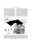
Fig. 9. Structural map of the Sardinia Channel-Sicily Straits area constructed on the basis of the reflection seismic lines of Fig. 3. This
shows the correlation between land and sea tectonic elements and thrust systems. I = Eastem Sardinia structural element; 2 = Kabylian-
Calabrian element; 3 = Sicilian-Maghrebian inner tectonic element; 4 = Sicilian-Maghrebian outer tectonic element: a= Sicanian TS,
b = Outer Carbonate TS, c= Gela TS; 5 = foreland or deformed foreland deposits: a= Plio-Pleistocene cover, b = Miocene clastic-
carbonatic deposits, c = Lower Miocene to Triassic carbonate substratum; 6 = volcanics; 7 = main thrust fronts; 8 = thrusts; 9 = strike-slip
faults; l O = structural axes; I I = normai faults. STF = Sardinia Thrust Front; DTF = Drepano Thrust Front; ETF = Egadi Thrust Front;
ATF = Adventure Thrust Front; GTF =Gela Thrust Front. The structural map is based on data collected by the authors.