
Page 25 - UNEP_MAP2015
P. 25
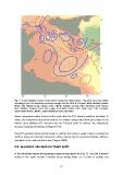
Fig. 7: A very simplified scheme of the flows crossing the Sicily Channel. The paths have been drawn
according to the SSH map from myOcean average data for 2010-2013 period. MAW, Modified Atlantic
Water; AIS, Atlantic Ionian Stream; ATC, Atlantic Tunisian Current; ABV, Adventure bank Vortex;
MCC, Maltese Channel Crest; ISV, Ionian shelf break Vortex; SDG, Sidra Gyre; LIW, Levantine
Intermediate Water; EMDW, Eastern Mediterranean Deep Water.

Warm anticyclonic eddies located on the south drive the ATC along its northern boundary. In
winter, the anticyclonic structures contract in a stable nucleus (the Sidra gyre) close to the
African coast allowing ATC intrusion over the Tunisian shelf. In summer, the anticyclonic
structure expands westwards, limiting the ATC.

The ATC spreads into the central Ionian in summer but rarely in winter. Likely It reaches the
northern Ionian Sea through anticyclonic eddies captured by the prevalent clockwise offshore
circulation in the north-central Ionian (Ciappa, 2009).

3.2 Levantine Intermediate Water (LIW)

In the subsurface layers the topography plays an important role (Fig. 7). The LIW is formed
mainly in the north eastern Levantine basin during winter as a result of cooling and

                                                            22