
Page 3 - Klaoudatos_Kapiris_2016
P. 3
characteristics. (Lascaratos et al., 1999). Low salinity Atlantic water (AW) that enters
in the upper layer of the Gibraltar Strait is transformed to saline Mediterranean
water that subsequently exits into the Atlantic via the lower layer. Although the
surface AW progressively loses its characteristics through mixing and evaporation
during its travel to the east, (salinity rising from 36.15 at Gibraltar Strait, to 38.6 in
the eastern Levantine Basin according to Lacombe and Tchernia, 1972; Ozsoy et al.,
1989), the transformation to intermediate and deep water occurs in selected areas
within the basin (Wust, 1961). In these areas, favourable oceanic conditions and
extreme air–sea interaction processes lead to the downward mixing extending deep
into the water column.
Warm surface Atlantic water, already stripped of much of its nutrients by
phytoplankton growth in the surface of the Atlantic, flows through the narrow Strait
of Gibraltar and returns some 80–100 years later, having circulated the
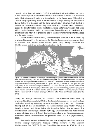
Mediterranean basin in an anticlockwise direction (Fig. 2).
Figure 2. A schematic summary of the major current and gyre systems of the Mediterranean Sea and
their seasonal variability. Thick line = winter circulation; thin line = summer circulation. A: Algerian
current and eddies; B: Branches of the Ionian stream; C: Tyrrhenian cyclonic current; D: summer
antyciclone in the eastern Tyrrhenian Sea; E: Ligurian-Provenc¸al current; F: Lions gyre; G: Syrte
anticyclone; H: mid-Mediterranean jet; I: Shikmona and Mersa-Matruth gyres system; J: Cilician and
Asia Minor current; K: Rhodes gyre; L: Iera-Petra gyre; M: western Cretan gyre; N: Pelops gyre; O:
Ionian cyclonic current; P: southern Adriatic gyre; Q: eastern Adriatic coastal current; R: western
Adriatic coastal current; S: western Ionian gyre. Modified after Pinardi and Masetti (2000). (Bianchi,
2007).
During its passage eastward, its nutrients are decreased even more by
phytoplankton (Bethoux et al., 1997) while climatic factors such as evaporation have
resulted in its salinity increasing by up to 10% (Milliman et al., 1992). The water
flowing out of the Mediterranean, the Mediterranean Deep Water (MDW) is
therefore denser and flows below the incoming lighter Atlantic water. The
Mediterranean Sea displays a specific hydrology, with well-identified water masses
in each sub-basin and at different depths. One peculiarity is a homogeneous deep-
water layer below 250 m that does not get colder than 12–13 8 °C (Lejeusne et al.,
2010).
The Mediterranean is divided into the four subregions described under the
Marine Strategy Framework Directive (MSFD), namely: (i) the Western
Mediterranean Sea (WMED); (ii) the Central Mediterranean Sea (CMED); (iii) the