
Page 5 - Gianguzzi_2016
P. 5
JOURNAL OF MAPS 849
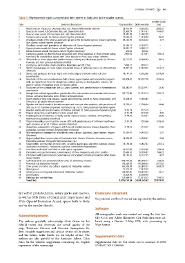
Table 1. Phytocoenotic types surveyed and their extent in Sicily and in the smaller islands.
Smaller islands
Code Synthetic description Total area (ha) Sicily area (ha) (ha)
1 Mediterranean maquis (cl. Quercetea ilicis, ord. Pistacio-Rhamnetalia alaterni) 21,415.94 18,333.93 3082.01
2 Quercus ilex woods (cl. Quercetea ilicis, ord. Quercetalia ilicis) 22,561.29 21,417.81 1143.47
3 Quercus suber woods (cl. Quercetea ilicis, ord. Quercetalia ilicis) 21,482.58 21,482.58 –
4 Castanea sativa woods (cl. Querco roboris-Fagetea sylvaticae) 11,539.43 11,518.96 20.47
5 Deciduous woods of the Quercus pubescens gr. and other deciduous species (classes: Quercetea 68,753.96 68,750.23 3.74
ilicis, Querco roboris-Fagetea sylvaticae)
6 Deciduous woods with prevalence of other oaks (cl. Querco-Fagetea sylvaticae) 25,348.73 25,348.73 –
7 Fagus sylvatica woods (cl. Querco roboris-Fagetea sylvaticae) 16,285.17 16,285.17 –
8 Betula aetnensis woods (cl. Querco roboris-Fagetea sylvaticae) 361.62 361.62 –
9 Coniferous woods: (a) thermophilous pinewoods with Pinus halepensis or Pinus pinaster subsp. 7963.94 7571.61 392.33
hamiltonii; (b) mesophilous woods with Taxus baccata or Pinus nigra subsp. calabrica
10 Shrublands on forest edges with predominance of thorny and deciduous species (cl. Rhamno- 35,717.07 35,696.93 20.14
Prunetea, ord. Pyro spinosae-Rubetalia ulmifolii)
11 Orophylous cushion-like shrubs (Madonie Mountains and Mt. Etna) 5398.14 5398.14 –
12 Shrubs and garrigues on rocky ridges and eroded slopes of carbonate nature (cl. Rosmarinetea 13,857.16 12,243.93 1613.22
officinalis)
13 Shrubs and garrigues on rocky ridges and eroded slopes of silicate nature (cl. Cisto- 78,147.16 72,832.88 5314.28
Lavanduletea)
14 Grasslands of the xeric-mediterranean belt (classes Lygeo-Stipetea and Artemisietea vulgaris) 145,004.02 142,027.39 2976.63
with: (a) Hyparrhenia hirta; (b) nitrophilous-ruderal species; (c) Brachypodium retusum; (d)
pioneer species of badlands areas; (e) Arundo collina
15 Grasslands of the submountain belt (cl. Lygeo-Stipetea), with predominance of Ampelodesmos 103,282.47 103,259.41 23.06
mauritanicus
16 Mesophilous and sub-hygrophilous grasslands of the submountain and mountain belts (classes: 152,713.86 15,1210.14 1503.72
Festuco valesiacae-Brometea erecti, Molinio-Arrhenatheretea)
17 Dwarf woods of xeric river terraces, coastal and sometimes inland (cl. Nerio-Tamaricetea), with 15,404.83 15,404.83 –
Tamarix sp. pl. and/or Nerium oleander
18 Riparian and dwarf woods of the submountain and mountain river stretches, with prevalence of 13,793.41 13,768.94 24.48
Salix sp. pl. (cl. Salicetea purpureae) and Populus sp. pl. (cl. Salici purpureae-Populetea nigrae)
19 Riparian woods with predominance of Platanus orientalis (cl. Salici purpureae-Populetea nigrae) 3125.19 3125.19 –
20 Pioneer glareicolous communities of river gravel beds 6125.78 6121.29 4.49
21 Psammophilous communities of sandy coastal stations (classes: Cakiletea, Ammophiletea, 3174.76 3120.81 53.96
Helichryso-Crucianelletea maritimae)
22 Chasmo-halophilous communitites on sea cliffs with predominance of Crithmum maritimum 2132.29 1055.66 1076.63
and Limonium sp. pl. (cl. Crithmo maritimi-Staticetea)
23 Halophilous communities of lagoons, salt flats and brackish marshes (classes: Ruppietea, Thero- 3174.42 3142.57 31.85
Suaedetea, Juncetea maritimi, Sarcocornietea fruticosae)
24 Halo-nitrophilous communities of badlands areas (classes: Saginetea, Lygeo-Stipetea, Pegano- 14,439.44 14,433.53 5.91
Salsoletea)
25 Hygro-hydrophilous communities of freshwater lakes (classes: Charetea, Lemnetea minoris, 14,496.89 14,496.21 0.68
Potametea pectinati, Phragmito-Magnocaricetea, etc.)
26 Chasmophitic communities of rocky cliffs, including quarry areas and lithic outcrops (classes: 11,138.78 10,857.67 281.12
Asplenietea trichomanis, Parietarietea judaicae, Anomodonto-Polypodietea)
27 Lava flows and naked lava fields or with sparse vegetation 16,415.09 15,910.80 504.28
28 Plantations with predominance (codominance) of Pinus halepensis and other conifers 57,681.10 56,796.87 884.22
29 Plantations with predominance (codominance) of Eucalyptus camaldulensis and/or other broad- 42,145.92 42,137.55 8.37
leaved species
30 Cultivated lands and temporary fallow lands (cl. Stellarietea mediae) 846,470.20 845,948.17 522.03
31 Vineyards (cl. Stellarietea mediae) 142,558.83 140,386.99 2171.83
32 Olive groves and other dry cultural aspects (cl. Stellarietea mediae) 336,528.59 332,899.29 3629.29
33 Hazel groves 12,411.27 12,411.27 –
34 Citrus groves and irrigated orchards (cl. Stellarietea mediae) 158,592.85 158,559.34 33.51
35 Greenhouses 15,608.46 15,608.46 –
36 Buildings and out-buildings 125,064.91 123,318.57 1746.34
Total (ha) 2,570,315.54 2,543,243.47 27,072.07
fall within protected areas, nature parks and reserves, Disclosure statement
as well as SCIs (Sites of Community Importance) and
No potential conflict of interest was reported by the authors.
SPAs (Special Protection Areas), sparse both in Sicily
and in the smaller islands.
Software
All cartographic work was carried out using the Esri Arc-
Acknowledgements
GIS 9.1/10 and Adobe Illustrator CS4. Field data were col-
The authors gratefully acknowledge Chris Orton for his lected using a Garmin E-Map GPS, with processing by
helpful review that improved the overall quality of the Map Source.
map, Tommaso Caloiero and Giovanni Spampinato for
their valuable suggestions and critical review of the paper,
and the Editor, Mike Smith, for his helpful advice. The Supplemental data
authors are also grateful to the Associate Editor, Colin
Pain, for his valuable suggestions concerning the English Supplemental data for this article can be accessed 10.1080/
expression of the manuscript. 17445647.2015.1094969