
Page 47 - Panuccio2012
P. 47
138 AGOSTINI AND PANUCCIO VOL. 44, NO. 2
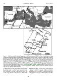
Figure 1. Solid lines: simplified plotted flyways reported by Strandberg et al. (2008) for Western Marsh Harriers (Circus
aeruginosus) passing through the central Mediterranean and via the Balearic Islands, as estimated using satellite telemetry.
Sketched lines: the alternative flyway along the Corsica-Sardinia corridor and the expected autumn routes used by
Western Marsh Harriers crossing the Mediterranean Sea as suggested by observations at the following watchsites: Island
of Elba (1), 42u469N, 10u169E; Island of Pianosa (2), 42u359N, 10u049E; site of the radar study near Malaga (3), 36u439N,
4u069W; Circeo Promontory, 41u149N, 13u039E; Island of Capri, 40u339N, 14u139E; Mount Covello (Calabrian Apennines),
38u499N, 16u249E; Island of Ustica, 38u429N, 13u099E; Island of Panarea, 38u389N, 15u039E; Aspromonte National Park
(area of the Strait of Messina), 38u139N, 15u559E; Island of Marettimo, 37u589N, 12u039E; Island of Pantelleria, 36u479N,
11u599E; Island of Malta, 35u549N, 14u269E; Pelagie Islands (Linosa: 35u539N, 13u159E; Lampedusa: 35u309N, 12u349E);
Cap Greco (4; Cyprus), 34u589N, 34u049E.
ern Marsh Harriers, being larger than males, are more 1995, Simmons 2000). For this reason, males may have
likely than males to capture larger prey (waterfowl) a stronger tendency to migrate earlier and further
and, probably, to tolerate colder temperatures and after leaving their breeding or premigratory stopover
to fast longer (Newton 1979, Kerlinger 1989, Clarke areas (Agostini and Logozzo 2000, Agostini et al. 2003,
47