
Page 4 - Cipriano_Madonia_alii_2017
P. 4
GEOMORPHOLOGICAL EVOLUTION OF WESTERN SICILY, ITALY 83
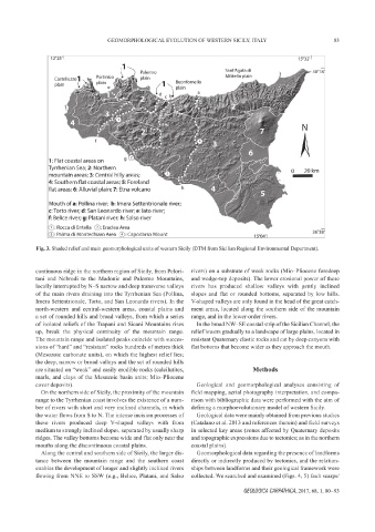
Fig. 3. Shaded relief and main geomorphological units of western Sicily (DTM from Sicilian Regional Environmental Department).
continuous ridge in the northern region of Sicily, from Pelori- rivers) on a substrate of weak rocks (Mio–Pliocene foredeep
tani and Nebrodi to the Madonie and Palermo Mountains, and wedge-top deposits). The lower erosional power of these
locally interrupted by N–S narrow and deep transverse valleys rivers has produced shallow valleys with gently inclined
of the main rivers draining into the Tyrrhenian Sea (Pollina, slopes and flat or rounded bottoms, separated by low hills.
Imera Settentrionale, Torto, and San Leonardo rivers). In the V-shaped valleys are only found in the head of the great catch-
north-western and central-western areas, coastal plains and ment areas, located along the southern side of the mountain
a set of rounded hills and broad valleys, from which a series range, and in the lower-order rivers.
of isolated reliefs of the Trapani and Sicani Mountains rises In the broad NW–SE coastal strip of the Sicilian Channel, the
up, break the physical continuity of the mountain range. relief lowers gradually to a landscape of large plains, located in
The mountain range and isolated peaks coincide with succes- resistant Quaternary clastic rocks and cut by deep canyons with
sions of “hard” and “resistant” rocks hundreds of metres thick flat bottoms that become wider as they approach the mouth.
(Mesozoic carbonate units), on which the highest relief lies;
the deep, narrow or broad valleys and the set of rounded hills
are situated on “weak” and easily erodible rocks (calcilutites, Methods
marls, and clays of the Mesozoic basin units; Mio–Pliocene
cover deposits). Geological and geomorphological analyses consisting of
On the northern side of Sicily, the proximity of the mountain field mapping, aerial photography interpretation, and compa-
range to the Tyrrhenian coast involves the existence of a num- rison with bibliographic data were performed with the aim of
ber of rivers with short and very inclined channels, in which defining a morphoevolutionary model of western Sicily.
the water flows from S to N. The intense incision processes of Geological data were mainly obtained from previous studies
these rivers produced deep V-shaped valleys with from (Catalano et al. 2013 and references therein) and field surveys
medium to strongly inclined slopes, separated by usually sharp in selected key areas (zones affected by Quaternary deposits
ridges. The valley bottoms become wide and flat only near the and topographic expressions due to tectonics; as in the northern
mouths along the discontinuous coastal plains. coastal plains).
Along the central and southern side of Sicily, the larger dis- Geomorphological data regarding the presence of landforms
tance between the mountain range and the southern coast directly or indirectly produced by tectonics, and the relation-
enables the development of longer and slightly inclined rivers ships between landforms and their geological framework were
flowing from NNE to SSW (e.g., Belice, Platani, and Salso collected. We searched and examined (Figs. 4, 5) fault scarps/
GEOLOGICA CARPATHICA, 2017, 68, 1, 80 – 93