Page 24 - MSc_thesis_R A Kil
P. 24

0                  1000          2000 km

                               Eurasian plate                                                    Pontic Mnts

                               Alps Carpathians                                        Anatolian plate

                    Pyrenees   Apennines           Dinarides                                      Taurus      Caucasus

   Iberian plate                                              Rhodopes

            Betics                                            Hellenides
         Rif
                                                                                                                            Alborz

                    Atlas                                                                                           Zagros

                              African plate

   Alpine fold & thrust belt   Legend                         Plate velocity           Arabian plate
                                      Major fault
                                                              Crustal movement
   Neogene extensional basin   Thrust fault                                                                                         Hajar
                                                              Oceanic spreading
   Neogene oceanic crust       Strike-slip fault              ridge

   Old (Tethys) oceanic crust  Normal fault

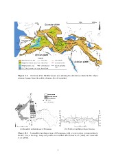
   Figure 2.3 – Overview of the Mediterranean area showing the structures related to the Alpine
   orogeny. Image from the public domain, free of copyright.

                    X’                             Quaternary deposits
                                                   Monte Santa Caterina Unit
                                                   Punta Faraglione Unit
                                                   Thrusts
                                                   Strike-slip faults

                                                                                 SN
                                                                                 X X’

                                                                                 500 500

                                                                                 250 250

                                                                                 0m 0m

                                                                                 ?-250                                                     -250

0  1 km  2 km       X                                                            -500  0 500 1000 m                                        -500

   (a) Simplified geological map of Favignana.                                          (b) Profile trough Monte Santa Caterina.

   Figure 2.4 – A simplified geological map of Favignana, with a cross section corresponding to
   the XX’ line in the map. Map and profile are modified after Abate et al. (1997) and Tavarnelli
   et al. (2003).

                                                                              7
   19   20   21   22   23   24   25   26   27   28   29