Page 3 - Malatesta
P. 3

Alberto Malatesta: 20 years of activity at the Geological Survey of Italy                 13


                                                                                      was promulgated by the  Italian governe-
                                                                                      ment to edit, update and publish the Geo-
                                                                                      logical Map of Italy at scale 1:100.000 and
                                                                                      the related Illustrative Notes. All Italian Uni-
                                                                                      versities, public and private organizations
                                                                                      and Autonomous Regions took part to such
                                                                                      activity, under  the qualified supervision of
                                                                                      the Geological Committee, headed by Ardi-
                                                                                      to Desio. Malatesta became part of  the
                                                                                      staff of the during such a period of intense
                                                                                      activity in almost every scientific research
                                                                                      sector both in the field and in the laborato-
                                                                                      ries. During his work at the Geological Sur-
                                                                                      vey of Italy, A. Malatesta contributed to the
                                                                                      elaboration of many geological sheets, car-
                                                                                      rying out both the geological survey of the
                                                                                      Plio-Pleisticene units and the palaeontolog-
                                                                                      ical analyses on the fossil remains he had
                                                                                      collected.  In particular, he  worked at the
                                                                                      realization of the following geological
                                                                                      sheets: N° 111 “Livorno”, N° 272 “Gela”,
                                                                                      N° 192  “Alghero”, N° 193  “Bonorva”,
                                                                                      N° 163 “Lucera”, N° 175 “Cerignola”,
                                                                                      N° 197 “Amalfi”, N° 149 “Cerveteri”, N° 121
                                                                                      “Montepulciano”, N° 122 “Perugia”, N° 127
                                                                                      “Piombino”, N°  148 “Vasto”, N° 115  “Città
                                                                                      di Castello”, N° 173  “Benevento”, N° 167-
                                                                                      168 “Isola Rossa - La Maddalena”, N° 169
                                                                                      “Caprera”, N° 256 “Egadi Islands” (unpub-
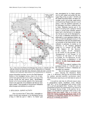
                                                                                      lished) (Fig. 2).
                                                                                          In Fig. 3 the original headings of the
                                                                                      geological sheets at 1:100.000 scale, to
                                                                                      the realization of which A. Malatesta col-
                                                                                      laborated, are reported.
                                                                                          Not all the above mentioned sheets
                                                                                      were featuring the Illustrative  Notes
                          scarce information has been found in the Staff Historical   (Tab. 1). A. Malatesta, although not mentioned among
                          Archive of the  Geological Survey, since a  lot of docu-  the authors, provided scientific contributions about
                          ments have gone lost due to the various movings of the   Plio-Pleistocene macrofauna and field data for some of
                          Survey during the last twenty  years. Nevertheless,   them.
                          thanks to the annual activity reports of the Survey pub-  It is worth to note that, for different reasons (lack
                          lished in the appendix of the Bollettino del Servizio Geo-  of topographical bases,  insufficient funds, reduced
                          logico d’Italia, it was possible to find precious indications   staff,  etc.), not all the  geological field  surveys ended
                          about charges and activities he carried out.     with a printed  geological sheet. Anyway, even these
                                                                           unpublished activities are documented in the archive of
                                                                           the Geological  Survey of Italy. In the  archive, for ex-
                          2. GEOLOGICAL SURVEY ACTIVITY                    ample, it is recorded the geological field survey of the
                                                                           Sheet  N° 256 “Isole  Egadi”. Figs. 4, 5, 6  and 7 illu-
                                               nd
                              After the end of the 2  World War, noticeable re-  strate the original handmade geological maps of the
                          search founds were assigned to the Geological Survey   Favignana and Marettimo  islands  and the relative  le-
                          of Italy. In 1960 the Law 3-1-1960 n. 15 (“Sullo” Law)    gends with autograph annotations.
   1   2   3   4   5   6   7   8