
Page 2 - 1Agostini_wind_patterns_honey_buzzard_ABR2016
P. 2
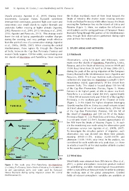
160    N. Agostini, M. Gustin, J. von Hardenberg and M. Panuccio


          (Aquila  pennata; Agostini  et  al.,  2015).  During these   the Sicilian mainland,  most of them head towards the
          movements, European Honey Buzzards sometimes         Straits of Messina (the shorter  water  crossing between
          interrupt their continuous, powered flight over water and   Sicily and Italian Peninsula) while others bypass the Straits
          concentrate  over  small  islands to exploit  thermals  and   crossing the Tyrrhenian Sea via the islands of Ustica and
          undertake  further  crossing at  higher altitude (Agostini,   Panarea  (Figure 1).  Here, we analyse the influence  of
          2002; Panuccio et al., 2004, 2013; Meyburg et al., 2010,   wind patterns on the spring pathways of European Honey
          2013; Agostini and Panuccio, 2015).  This strategy could   Buzzards flying through this portion of the Mediterranean
          lower  the  risk  of facing  unpredictable weather  changes   area, through field observations performed during eight
          during the crossing,  and may perhaps result effective   years at these five watch sites.
          from the point of view of a conservative strategy (Agostini
          et al., 2005a, 2005b, 2007). When crossing the central
          Mediterranean, these raptors fly through  the Channel   2.  STUDY AREAS AND METHODS
          of Sicily, between the Cap Bon Peninsula (Tunisia) and
          western Sicily (approx. 150 km wide), concentrating over   2.1 Fieldwork
          the islands of Marettimo and Pantelleria. Once reached
                                                               Observations,  using  binoculars and telescopes,  were
                                                               made over the islands of Marettimo, Pantelleria, Ustica,
                                                               Panarea, and at the Straits of Messina, between 09:00 and
                                                               19:00 (local time) from 20 April to 20 May 2006–2013,
                                                               during the peak of the spring migration of the European
                                                               Honey Buzzard in the Mediterranean basin (Agostini and
                                                               Panuccio, 2005). This 8 year multisite study allowed the
                                                               collection of a large data set. Marettimo is a small (12 km²)
                                                               mountainous  island, approximately  30 km  distant  from
                                                               western Sicily. This island is located about 130 km NE
                                                               of the Cap Bon Promontory (Tunisia,  Figure 1).  Monte
                                                               Falcone is its highest  point,  at 686  m  above sea  level.
                                                               Pantelleria is a volcanic island (84 km²), approximately
                                                               110 km SW of western Sicily and 70 km SE of the Cap Bon
                                                               Peninsula, in the southern part of the Channel of Sicily
                                                               (Figure 1). In this island the highest elevation (Montagna
                                                               Grande) reaches 836 m. Ustica is a small volcanic island
                                                               (8.5 km²) about 60 km N of western Sicily, 270 km NE
                                                               of  the  Cap  Bon  Promontory  (Tunisia),  140  km NE of
                                                        (a)
                                                               the  island  of  Marettimo and 230  km W of  the  Italian
                                                               Peninsula (Figure 1). Like Pantelleria and Ustica, Panarea
                                                                                       2
                                                               is a volcanic island (3.5 km ), located approximately 65
                                                               km NW from the Straits of Messina (Figure 1). At each
                                                               site the monitoring was made using the observation post
                                                               of previous  surveys (see Agostini  et  al., 2005b,  2007).
                                                               To investigate the circadian  pattern  of migration,  each
                                                               observation  day was divided into  three time periods:
                                                               morning (09:00–11:59),  midday (12:00–14:59)  and
                                                               afternoon (15:00–19:00, solar time). In the analysis, we
                                                               considered for each watch site only peak days, i.e. those
                                                               in which at least 9% of the total number of birds counted
                                                               in the season was reported.


                                                               2.2 Wind data
                                                        (b)
                                                               Wind fields were obtained from ERA-Interim (Dee et al.,
          Figure  1 The  study  area  (Pnt=Pantelleria;  M=Marettimo;   2011), a  global atmospheric reanalysis product realised
          U=Ustica; P=Panarea; SoM=Straits of Messina; V=Ventotene)   by  assimilating available meteorological measurements
          (a) and approximate  paths  over  water  used  by European   within a state-of-the-art forecast model in order to estimate
          Honey  Buzzards during  spring  migration across the central   the  evolving  state of  the  global atmosphere. Gridded
          Mediterranean (b).                                   fields  of  relevant atmospheric variables are  available at