
Page 3 - CatraEgadi2006
P. 3
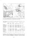
Fig. l. Map of the Egadi islands showing sampling sites (arrows). Inset: Map of the Mediterranean
Sea. Arrowhead indicates the location of the Egadi islands (inside the square).

Table 2. Sampling sites on the Egadi islands. In the depth column Mi = Midlittoral zone and O =

biologica! zero.

                  Abbre- L1titude Longitude  Date                    Depth in meters

                  viation CON)  (oE)         Spring Autumn

Favignana         PF 37°57'20" 12° 18'50"    03.06.01   26.09.01     Mi, O, - 1, -10,-20
Punta Faraglione                             29.05 .01  25 .0 9 .01  Mi,0, -1,-7
Punta Marsala     PM 37°54'55" 12°2 1'70"    29.05.01   27 .09.01    Mi, O, -l, -5, -7
Punta Longa                                  29.05.0 l  02.10.01     Mi, O, -l , -5, - 15,-25
Scoglio Corrente  PL 37°54'80" 12° 18' 10"   05 .06.01  02.10.01     Mi, O, -l, -10,-20, -30
Punta Sottile
                  se 37°55'00" 12° 17' IO"
Levanzo
Capo Grosso       So 37°56'25" 12° 16'20"
Punta Altare/la
Il Faraglione     CG 38°01 '35" 12°20'20"    o1.06.01   27.09.01     O, -l, -1 O, -20, -30, -40
Punta dei Sorei                              o1.06.0 l  29.09.01     0, -1,-10, -20
                  PA 37°59'64" 12°21 '30"                            Mi, O, - 1, - IO, -20,-30
Marettimo                                    31.05.0 l               Mi, O, -l , -5, - IO, -20
Punta Mugnone     Fa 37°59'27" 12° 19'60"
                  PS 38°00'60" 12°19'20"     31.05.01

                  Mu 37°59'70" 12°01'72"     08.06.01 01.10.01 Mi, O, -1,-10,-25

archipelago is 158 (l 03 Rhodophyta, 39 Ochrophyta, 16 Chlorophyta), while 127
species (97 Rhodophyta, 19 Ochrophyta, Il Chlorophyta) are new to the islands.
Conversely, IlO species (62 Rhodophyta, 33 Ochrophyta, 15 Chlorophyta) formerly

                                                   491