
Page 2 - First assessment of the vermetid
P. 2
372 PAOLO BALISTRERI ET ALII
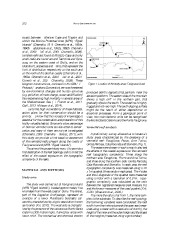
coasts between Zafferano Cape and Trapani and Figure 1. Location of the study areas: Favignana Island.
within the Marine Protected Area (MPA) “Egadi
Islands” (Chemello, 1989; Chemello et al., 1990a, produced detritic deposits that partially mask the
1990b; Badalamenti et al., 1992a, 1992b; Chemello abrasion platform. The eastern side of the mountain
et al., 2000; Dieli et al., 2001; Chemello, 2009). shows a high cliff in the northern part, that
Isolated reefs are found at Milazzo Cape and only gradually dips to the south. The coastline is highly
small reefs are found around Taormina and Syra- rugged and not very high. The south dipping surface
cuse, on the eastern coast of Sicily, and on the might be the result of either depositional or
Islands of Lampedusa and Ustica, that represent the erosional processes. From a geological point of
limit of distribution respectively on the south and view, two main tectonic units can be recognized:
on the north of the Sicilian coasts (Chemello et al., the Monte Santa Caterina and the Punta Faraglione.
1990a; Chemello et al., 2000; Dieli et al., 2001;
Consoli et al., 2008; Chemello, 2009). These Vermetid reef analysis
biogenic constructions, enclosed in the SPA/BIO
Protocol (Barcelona Convention) are now threatened A preliminary survey allowed us to locate six
by environmental changes and human activities study areas characterized by the presence of a
(e.g. pollution, climate change, ocean acidification) vermetid reef: Faraglione, Pozzo, Arre Turinu,
thus experiencing high mortality in several areas of Grotta Perciata, Cala Rotonda and Stornello (Fig. 1).
the Mediterranean Sea (Di Franco et al., 2011;
Galil, 2013; Milazzo et al., 2014). The areas were chosen in such a way to also test
the effects of the coastal exposure on the vermetid
Due to the high vulnerability of these habitats, reef topographic complexity. Three along the
action plans for their conservation should be a northern side: Faraglione, Pozzo and Arre Turinu,
priority. We know that the increase of knowledge is and three along the southern side: Grotta Perciata,
essential for the conservation and protection of this Cala Rotonda and Stornello. In each area the reef
highly valuable habitat. Since only a low percentage topographic complexity was measured using a 1m
of Sicilian vermetid reefs are subjected to conser- x 1m quadrat (three random replicates). The 4 sides
vation and many of them are not yet investigated and the 2 diagonals of the quadrat were measured
(Chemello, 2009; Chemello & Silenzi, 2011), with using a meter with a resolution of 0.01m. Topo-
this study we provide a first baseline assessment graphic complexity was calculated as the ratio
of the vermetid reefs present along the coasts of between the registered measures (real measure, Xi)
Favignana Island (MPA “Egadi Islands”). and the known measures of the used quadrat (Xn):
Xi/Xn (Graziano et al., 2009 ).
The aims of the present study were: i) to provide a
first description of the reef typology and ii) to test the The more the ratio is far from 1, the more com-
effect of the coastal exposure on the topographic plex is the substrate. To describe the reef typology
complexity of the reefs. the following variables were considered: the reef
width from the inshore towards the open sea (meas-
MATERIAL AND METHODS ured using a meter with a resolution of 0.01m), the
height of the inner and the outer margin and the slopes
Study area of the margins (measured using a goniometer).
The study was carried out at Favignana Island
(MPA “Egadi Islands”), located approximately five
kilometers from the west coast of Sicily. The Island,
part of the Aegadian Archipelago, represent an
example of a lower Pleistocene bioclastic cal-
carenite, characterized by a typic association known
as foramol (Kil, 2010). The west side is character-
ized by the presence of the calcareous Monte Santa
Caterina (300 metres high), flanked by areas with
lower relief. The mechanical and chemical erosion