
Page 1 - GainguzziPaniniCusimano
P. 1
Phytosociological survey vegetation map of Sicily (Mediterranean region)
Lorenzo Gianguzzi3 *, Fabio Papinib and Dario Cusirnano3
"Department of Agricultural and Forest Sciences, U niversità degli Studi di Palermo, ltaly
bAgristudio S.r.l., Firenze, Italy
*Corresponding author. Email: lorenzo.gianguzzi@unipa.it
Methods
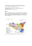
Figure S1 is a schematic lithological map of Sicily (from Fierotti, Dazzi, & Rairnondi, 1988,
redrawn), including the smaller circum-Sicilian islands. Figures S2 and S3 show the thematic
maps, respectively, of average annua! temperatures and rainfall of the region, produced on
the basis of the climate data from the Regional Hydrographic Service covering the 1965-
1994 period (Drago, 2005).
. . ·-.. ,. .... .._, _ • • .AEOUAH 15\.ANDI " o
N
·--0"""""'.."""'''-·
D~~::::ylormllltOnt
o·-·--,.,..,.,_D Sol>dy<lbr-c..,_,
. C.O'belnl(c:to~·IOI'I· ~to....
doktmoCM: llmn10MS ~~. ..c
t:)CI~ enclet~Jonnlbonl
• c•~_..,.,....;_,..._,"',_
·---~•f'DIMc ......
OCIII)"eY~KinS KII'T1.tlmeawtthiCDir"SJic:lmef.U:
sel'ody qu.v..ren•te lewfs
Figure S l. Schematic lithological map of Sicily (from Fierotti, Dazzi, & Raimondi, 1988, redrawn).