
Page 33 - Lloreta_alii_2001
P. 33
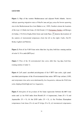
LEGENDS


                  Figure 1. Map of the western Mediterranean  and adjacent North Atlantic. Arrows

                  indicate spawning migration routes of bluefin tuna and grey areas the known spawning


                  sites in the Mediterranean Sea (from Mather et al., 1995). Numbers denote the locations

                  of the traps: (1) Medo das Casas, (2) Sidi Daoud, (3-5) Favignana, Formica and Bonagia


                  (6) Saline, (7-9) Porto Paglia, Porto Scuso and Isola Piana.  T  denotes the locations of

                  the stations of instrumental temperature  (from the left to the right): Cadix, Dar-El-


                  Beida, Cagliari and Palermo.


                  Figure 2. Plots of the 9 BFT time series (thin line: log data; bold line: running median

                  of order 3). N is catch (BFT/year)


                  Figure 3. Plots of the 10 environmental time series (thin line: log data; bold line:


                  running median of order 3).


                  Figure 4. Left panel: smoothed periodograms of  the 9 BFT time series, right panel:


                  smoothed periodograms of the 10 environmental time series. BFT (trap catches), LOD,

                  and temperature time series were dominated by low frequencies, whereas the NAO time


                  series displayed both high and low frequencies.


                  Figure 5. Box-plots of the p-values of the  linear regressions between the BFT time

                  series and: (a) the NAO index from Hurrell  (N = 6 regressions), Jones (N = 9) and

                  Appenzeller (N = 9), (b) the LOD index  (N = 8), (c) the Northern Hemisphere


                  temperatures from Jones (N = 6) and D’Arrigo (N = 9), (d) instrumental temperatures


                                                            34