
Page 3 - 122789121769ClaudioCSR2008
P. 3
ARTICLE IN PRESS 247
C. Lo Iacono, J. Guille´n / Continental Shelf Research 28 (2008) 245–256
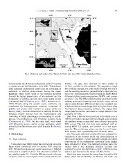
Fig. 2. Study area and location of the ‘‘Mazara del Vallo’’ wave buoy. SMC: Sicilian Maghrebian Chain.
Consequently, the Holocene sedimentary prism is very thin bottom. The data were recorded at water depths of
or absent around the Marettimo inner shelf. The isolation 10–50 m, parallel to the coastline. The acquisition range
from mainland sedimentary inputs and the reworking of was 75 m per channel, the total swath coverage was 150 m
sediments in shallow environments during the recent and the resulting resolution, perpendicular to the track line,
highstand phase (6000 years to the present) probably was 0.3 m. Positioning was achieved using the Skyfix-Racal
favored the limited preservation of fine sediment and the differential global positioning system (DGPS), with a mean
dominance of pebbles, gravels, and coarse sands on the accuracyo1 m. The SSS towfish position was related to the
continental shelf (Colantoni et al., 1993; Hermand et al., antenna position by inserting cable layback values such as
1999). Mostly along the western sector, sediments are ship–towfish distance. SSS record lines were compiled into
constituted by heterogeneous mixtures composed of a high-resolution mosaic image (0.25 m) by Isis Triton Elics
pebbles and gravels with medium to coarse sands (Lo International data processing software. The digital slant
Iacono, 2004). The sand component is partially formed by range-speed correction permitted an image distortion not
bioclasts, mainly derived from the fragmentation and exceeding 10–20%.
reworking of biotic assemblages corresponding to coralli-
genous, pre-coralligenous, and Posidonia oceanica facies Data from a SSS survey carried out in the study area in
(Colantoni et al., 1993). On the outer shelf, mud mixed 1989 by the Italian Geologic Service allowed us to compare
with lithoclastic grains overlies coarser sediments, which the resulting mosaic images with data collected during the
probably form Marettimo paleo-shelf deposits (Lo Iacono, 2002 survey. The side scan data were gathered with an
2004). analog EGG 272 system, and printed on a wet paper
recorder. The positioning system was the Loran-C hyper-
3. Methodology bolic system, with a positioning error of about 100 m.
3.1. Data collection Van-Veen grab sediment samples (49) were collected for
calibration of the acoustic facies and characterization of
A side scan sonar (SSS) survey was carried out along the the bottom sediment. Further sediment samples and direct
Egadi Island continental shelf in October 2002 using the observations of the sedimentary structures (dune height)
SIS 1500 Benthos-Datasonics model operating at 100 kHz were obtained by dives. The sediment samples were pre-
and towed at a depth of about 15 m above the sea bed. For treated with a 6% hydrogen peroxide solution and
very shallow water (10–15 m), the SSS was towed on the sea analyzed for grain size distribution (Folk, 1974) by sieving
surface in order to avoid impacts of the towfish with the sea within a f/2 interval in the range of 0.063–32 mm.
Wave data were recorded by a wave buoy located in NW
Sicily (37131.50N–12132.00W), off Mazara del Vallo city