
Page 10 - Sulli_eall_2012
P. 10
150 Sulli A. et al.
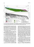
Fig. 11- Seismic reflection profile (below; Sparker 1 kJ) and stratigraphic interpretation of the middle (?)-late Quaternary sedimentary
succession buried beneath the continental shelf in the Gulf of Castellammare. The interpretative model images also a possible correla-
tion to the deposits outcropping along the coastal zone (see text for more detail; modified from Agate et al., 2005).
It shows predominantly oblique, medium and high ampli- and strongly reflective horizon on the slope, the seismic
tude reflectors of good lateral continuity, with foresets expression of the condensed section (sensu Loutit et al.,
gradients ranging from 4° to 10°. Seawards, reflectors 1988). In the inner shelf between the mouth of the No-
become parallel to the downlap surface and merge into cella River and the overhanging coast of Capo Rama
the high amplitude and laterally continuous upper slope and off the Freddo and Jato Rivers, acoustic masking
reflectors. At the base of these shelf-perched units, affects this surface (Fig. 11) suggesting the presence of
chaotic seismic facies and small superimposed mounds biogenic gas. The upper stratigraphic limit of the HST is
have been identified in close association to gullies and represented by the present day depositional surface
(sea bottom). The HST is marked by a thick prograding
canyons, cutting the outer shelf. wedge, which extends continuously from the inner as far
as the middle-outer shelf (Fig. 11). Analysis of the high-
The depocenters of FSST and LST lengthen paral- resolution seismic profiles has enabled the subdivision
lel to the paleomargin of the continental shelf in an E-W of HST into two parasequences, separated by an ero-
direction but the greatest thickness, exceeding 40 ms sional surface. The lower parasequence shows faintly
(t.w.t.), is identified near to the canyon heads. prograding geometries, shingled and oblique parallel,
while the upper is oblique tangential. The modern depo-
The top of the shelf margin units is a transgres- sitional surface truncates the topsets of the last parase-
sion erosional surface (transgressive surface of erosion, quence, suggesting the position of the modern fair-
Fig. 11); Nummedal & Swift, 1987) replaced in the upper weather base level at 20 m of depth.
slope by a drowning surface, without erosional features.
In the dip sections, the predominant seismic facies
The TST (Fig. 11) is bounded at the base by an ir- is oblique-sigmoid, with high amplitude and good lateral-
regular transgressive surface of erosion, with wave-cut ly continuous reflectors, which merge seawards with a
terraces and channel features, reaching 500 m in width slope of approximately 1,5°. In the strike sections, seis-
and 10 m in depth. The most striking feature is the ret- mic profiles show lateral variations of the facies: lobed
rogradational pattern of three parasequences separated facies with internal configurations of the hummocky type
by mixed (flooding and erosional) surfaces, extending overlap with tabular facies faintly clinostratified dipping
laterally throughout the area (Agate et al., 2005). The towards the southwest.
three sub-units display a progressive landward shift of
the coastal onlaps, which encroach between 98 m to 90 In the inner shelf, opposite the Freddo and the Jato
m, 75 m to 63 m, and 60 m to 45 m water depths. Rivers, HST is deformed by upslope migrating wave
structures (Fig. 15 in Agate et al., 2005), related to the
The downlap surface at the transition between
TST and HST corresponds to the maximum flooding
surface (sensu Vail, 1987). It correlates with a very wide