
Page 6 - Sulli_eall_2012
P. 6
146 Sulli A. et al.
Vito Lo Capo peninsula (Fig. 1). Here, a
sedimentary basin, more than 1000 m
deep, trends in a general north-south di-
rection across the upper slope.
The continental slope deepens to
1000 m, with gradient of 4-9°, and is in-
cised by numerous gullies and major can-
yons (Fig. 2). Slumping, scours and small
turbiditic fans are located at depths from
200 to 800 m, confirming the occurrence
of gravity-driven slope instability (Agate et
al., 2005).
The coastal belt includes several
rocky cliffs along the promontories border-
ing the Gulf of Castellammare (Capo San
Vito and Capo Rama), while a long beach,
up to several tens of meters wide, extends
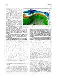
in the central sector. Fig. 5 - 3D shaded relief model (view from North-West) showing several gullies and
The continental shelf is wave-domi- canyon headscars indenting the shelf break along the southeastern sector of the Gulf
of Castellammare.
nated, with a mean tidal range of about 21
cm (Istituto Idrografico della Marina, units). As several Authors have documented along oth-
1982). The predominant wave direction is from north- er Mediterranean margins (Chiocci et al., 1991; Correg-
west, while the southwest and southeast are less fre- giari et al., 1996; Hernandez-Molina et al., 1994; Tes-
quent. Storm waves occur in winter to spring (November son et al., 2000; Trincardi & Field, 1991 among others),
to May) and vary in approach direction from northwest to the cyclic change of these attributes almost certainly is
northeast. a response to subsequent sedimentary environment
The continental shelf is 8 km width on the central variations controlled by Quaternary eustatic sea-level
part and in the eastern side of the gulf, but it is very nar- fluctuations.
row or absent along the rocky cliffs of the San Vito Lo The unconformity is a subaerial erosional surface
Capo peninsula. formed during the last eustatic sea level fall ended in the
The inner shelf, with gradient of 0.7°-1.0°, encom- LGM (20-18 ka) and shaped again during the Late Qua-
passes 0-50 m, while the outer shelf has a slope of 0.9°- ternary-Holocene sea level rise that generated a “trans-
1.2°. The central-western sector of the inner shelf is gressive surface of erosion” (Nummedal & Swift, 1987).
characterized by convex and concave breaks-in-slope As consequence of this polygenic genesis, the uncon-
bounding wave-cut terraces and paleo-cliffs; the seabed formity is punctuated by incised valley, submerged cliff
is punctuated by rocky outcrops and small biohermes. and isolated topographic relieves corresponding to out-
The Holocene coastal wedge is thicker in the cen- crops of the rocky substrate, mud volcanoes, biogenic
tral-eastern sector where the sea bed is rather even and mounds.
displays an up to 2° gradient in the inner shelf; the bath- This prominent unconformity is in turn the lower
ymetric gradient decreases seawards. The present day boundary of the sedimentary succession deposited dur-
shelf margin morphology arises from a former wave-cut ing the last eustatic change (last 125 ky), which can be
terrace mostly buried beneath a thin sheet of Holocene interpreted as a IV order depositional sequence (Late
sediments. Quaternary Depositional Sequence, LQDS). In the
The shelf break lies at depth of 130-190 m and LQDS we recognized four systems tracts, separated by
shows a scalloped shape in the southeastern sector be- basin-wide key surfaces identified by lateral termina-
cause of several gullies and canyon headscars indent- tions of reflectors, and deposited during specific seg-
ing the shelf margin (Fig. 5). Out of the canyon head- ment of the last sea level change. The LQDS extends
scars, the shelf break is a prograding, depositional above the continental shelf and upper slope along the
straight feature. Along the San Vito peninsula the shelf different sectors of the margin with considerably variable
break lies at depth of 60-100 m because of structural internal geometry and stratigraphic relationships with
control and abundant retrogressive mass movement the underlying units.
along the upper slope. In the small Bay of San Vito the
continental shelf is very narrow and the shelf break lies 5.1 Gulfs of Termini and Palermo
at depth of 80-100 m reflecting a structural control. In these sectors the stratigraphic features of the
LQDS and underlying Pleistocene succession are very
5. SEISMOSTRATIGRAPHIC SETTING AND FEA- uniform, so they will be illustrated together. We will de-
TURES scribe the systems tracts from the older to the younger.
Deposits accumulated during the sea level fall
Along the study area the continental shelf is char- form progradational sedimentary wedges perched along
acterized by an extensive unconformity eroding a sea- the shelf margin (Figs. 6-7). They are imaged by high
ward dipping mixed (lithoclastic/bioclastic) Pleistocene resolution seismic profiles with reflection-free seismic
succession. In the seismic reflection profiles these hori- pattern or thin, oblique tangential/parallel reflectors, 3.5°
zons can be assembled into packages of reflectors seaward sloping, locally involved in slumping. Wedges
showing specific seismic attributes (seismostratigraphic are up to 50 ms (t.w.t.) thick and up to 2 km wide; land-