
Page 4 - Sulli_eall_2012
P. 4
144 Sulli A. et al.
channel seismic profiles provided high resolution to high 4.1. Gulf of Termini
penetration data of the sedimentary succession. High In the Gulf of Termini, average gradient of shelf in-
resolution seismic profiles were mainly acquired employ-
ing a multi-tip sparker array, with a base frequency of creases sideways, up to 2.7° offshore Capo Zafferano,
around 600 Hz, fired each 12.5 m. Data were received with a shelf width ranging from 1.5 km to 8 km (Fig. 2).
with a single-channel streamer with an active section of The seabed appears rather even with the exception of
2.8 m, containing seven high-resolution hydrophones narrow coastal sectors where the substrate outcrops.
recorded for 3.0 s two way time (t.w.t.) at a 10 kHz (0.1
ms) sampling rate. Data processing was performed us- The inner shelf is regular and steep due to the
ing the following mathematical operators: traces mixing, depositional slope of the Holocene coastal sedimentary
time variant filters, automatic gain control, time variant wedge, while the outer shelf is less steep because the
gain and spherical divergence correction. The resulting Holocene sediments drape a sub-horizontal seabed.
signal penetration exceeded 400 ms (t.w.t.) and the ver- The prograding coastal depositional system in the inner
tical resolution reached 2.5 m at the seafloor. Medium to shelf developed during the Holocene as consequence of
high penetration seismic data were acquired by using the subaqueous delta coalescence of small rivers that
both high power sparker source coupled with single- flow to the coast (San Leonardo, Torto, Imera, Roccella
channel streamer and airgun coupled multi-channel and Piletto rivers). An abrupt seaward increase of the
streamer. The penetration ranges from 1 to 6 s (t.w.t.), sea bottom slope emphasizes the transition from the
with vertical resolution between 10 and 80 m. delta front (slope < 0.5°) to the prodelta (slope of 1°-2°).
In some areas, this submarine wedge is extended al-
The seismic lines were interpreted using seismic most to the shelf edge.
facies analysis, which allowed depositional units, char-
acterized by different seismic attributes, to be distin- Moving far from the entry points of the sedimen-
guished. The interpreted seismic lines were depth con- tary supply, towards the sides of the gulf, the inner shelf
verted adopting average velocities derived from lithostra- shows a rougher morphology of the sea bed character-
tigraphy and sonic log data collected in the southern and ized by break-in-slope, paleo-cliff and wave-cut terraces
western Sicilian offshore. partly buried beneath the thin Holocene sedimentary
sheet and the Cymodocea nodosa meadow, as offshore
4. GEOMORPHOLOGICAL FEATURES OF THE Termini Imerese, westward of the San Leonardo River
NORTHERN SICILY CONTINENTAL MARGIN mouth. In the western sector of the gulf, the continental
shelf is punctuated by small irregular, isolated relieves
In order to explain the geomorphological and seis- partly draped by Holocene sediments.
mostratigraphic features of the North Sicily continental
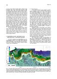
shelf we individuate some main sectors (Fig. 2), from E The shelf break is located at depth between 90
to W Gulf of Termini, Gulf of Palermo, Offshore Palermo and 145 m. Prograding pattern and straight trend are
Salient, Gulf of Castellammare. predominant, but at places a scalloped shelf break is
due to canyon headscars (Fig. 3). The upper slope is
steeper in the western sector, where a number of sub-
marine canyons develop with parallel thalweg, orthogo-
nal to the isobaths.
Fig. 2 - 3D shaded relief elevation model of the north-western Sicily mainland and offshore areas. The model shows the main morpho-
structures and geomorphologic features of the continental shelf to slope region. Intraslope Basin (e.g. Gulf of Castellammare and Gulf of
Palermo) are bounded by structural highs of bed rock. The upper slope is scoured by a number of submarine canyons and gullies. Ac-
cording to the elevation scale, the continuous red belt follows the continental shelf edge. The map also shows some of the main topo-
nyms used in this paper. The location of the figures illustrated in the paper is also shown.