
Page 15 - UNEP_MAP2015
P. 15
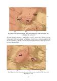
Fig. 5: Map of the Empedocle seamount, depth contours every 50 m. GHM, Graham bank; TRB,
                                              Terribile bank; NRT, Nerita bank.

The Pinne-Nameless Bank is a fault-bounded seamount located about 40 km SE of the
Graham bank at the same latitude as Pantelleria. It is a Cenozoic carbonate platform split
into two asymmetric sectors by a narrow valley at a depth of 200 m b.s.l. The largest plateau
is 4 km in diameter (Fig. 6).

   Fig. 6: Map of the Pinne-Urania-Nameless bank, depth contours every 100 m. PNB, Pinne bank;
                                                     NML, Nameless bank.

                                                            12