
Page 13 - UNEP_MAP2015
P. 13
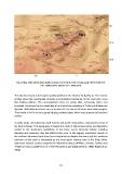
Fig. 3: Map of the Skerki bank, depth contours every 100 m. HCT, Hecate patch; KTH, Keith reef;
                                      BDL, Biddlecombe plateau; SLV, Silvia knoll.

The Adventure bank is the largest shallow platform in the Strait of Sicily (Fig. 4). The seismic
profiles show that considerably reduced unconsolidated sediments, for the most part, cover
this shallow platform. The unconsolidated strata are gently tilted, tectonically offset, and
truncated. Adventure bank is essentially a horst structure consisting of Tertiary and Mesozoic
deposits. Well-defined terraces are cut at about 110 m and at 140 m on some bank margins.
The terrace at 140 m forms a gently dipping seaward slope, which may represent a foreshore
surface.

A gentle slope, interrupted by small mounts and gentle depressions, characterizes most of
the bank surfaces. This topography is largely the result of alternating erosion and deposition
related to the Quaternary oscillations of sea level; recent structural activity, including
diapirism and volcanism, also has affected this zone. In this respect, submarine mounts on
the northern Adventure bank have been interpreted as diapiric structures and the southeast
extension of this bank is interpreted as the most active volcanic area in the Strait. Minor
submarine volcanic centres recognized in Adventure plateau (Anfitrite, Cimotoe, Galatea and
Tetide) are also considered to be of Plio-Pleistocene age (Calanchi et al., 1989; Rotolo et al.,
2006).

                                                            10