
Page 9 - UNEP_MAP2015
P. 9
bottom) topographic structures such as seamounts, underwater volcanoes, banks, shoals,
hills, patches, rises, etc. have also allocated according the EMODnet bathymetry map using
10m depth interval at 450 m horizontal grid (Tab. 1; Tab. 2; Fig. 2).
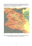
Fig. 1: The Sicily Channel-Tunisia Plateau main features as described in the text. The red line bounds
the so-called Pelagian Province (Klett, 2001); IAP: Ionian Abyssal Plain.
6