
Page 10 - UNEP_MAP2015
P. 10
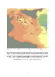
Fig. 2: Position of the seamounts, banks, submarine volcanoes and other rising structures in the Sicily
Channel. The blue dots indicate the shallower bathymetry of those structures of which it was possible
to find the name from scientific literature or other sources; red dots indicate the positions of unnamed
 structures. For both, the geographic coordinates have been estimated on the basis of the EMODnet

         bathymetry map, with 10 m depth interval at 450 m horizontal grid. For the code – name
                      correspondence see Tab. 1 and Tab. 2. Depth contours every 200 m.

                                                             7