
Page 4 - copy_of_FalconiS8.7
P. 4
4
identification of possible displacements along the cliffs, several scanning spaced
in time will be acquired (Abellán et alii, 2010; Stock et alii, 2012). Various Digital
Terrain Models will be processed and their comparison will permit to derive
displacement maps of the observed cliffs. The GPS, instead, is used only in Cala
Rossa and is directed at the control of 4 points identified in specific portions
behind the cliff edge. The GPS technique will permit to identify movements with
sub-centimetric detail level. For this purpose a local GPS network has been
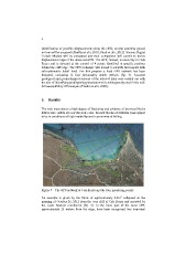
designed, consisting in four presumably stable vertices (fig. 3). Accurate
geological and geomechanical surveys of the selected sites were carried out with
the aim of identifying predisposing parameters to be subsequently used in the rock
fall susceptibility GIS analysis (Frattini et alii, 2008).
5. Results
The rock mass shows a high degree of fracturing and evidence of previous blocks
falls is also visible all over the study area. Several blocks of different sizes appear
to be in conditions of high instability and in proximity of falling.
Figure 3 – The GPS network at Cala Rossa and the four measuring points
An example is given by the block of approximately 0.3m3 collapsed on the
morning of October 26, 2012 from the west cliff of Cala Rossa and recorded by
the Laser Scanner monitoring (fig. 4). In the inner part of the same cliff,
approximately 25 meters from the edge, have been recognized two important