
Page 2 - Assessment
P. 2
2 D. Melaku Canu et al. / Marine Pollution Bulletin xxx (2015) xxx–xxx
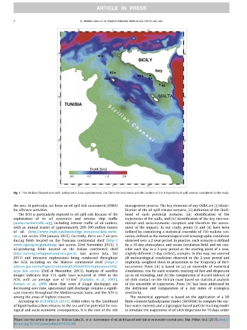
Fig. 1. The Sicilian Channel area with bathymetric data superimposed, the finite element mesh and the location of the 6 hypothetical spill sources considered in the study.
the area. In particular, we focus on oil spill risk assessment (OSRA) management process. The key elements of any OSRA are (i) identi-
for offshore activities. fication of the oil spill release scenario, (ii) definition of the likeli-
The SCH is particularly exposed to oil spill risk because of the hood of each potential scenario, (iii) identification of the
exploitation of its oil reservoirs and intense ship traffic trajectories of the spills, and (iv) identification of the key environ-
(www.marinetraffic.org), including intense traffic of oil tankers, mental and socio-economic receptors and therefore the assess-
with an annual transit of approximately 200–300 million tonnes ment of the impacts. In our study, points (i) and (ii) have been
of oil. (http://www.itopf.com/knowledge-resources/data-statis- defined by considering a statistical ensemble of 730 realistic sce-
tics/, last access 15th January 2015). Currently, there are 7 oil-pro- narios, defined as the meteorological and oceanographic conditions
ducing fields located on the Tunisian continental shelf (http:// observed over a 2-year period. In practise, each scenario is defined
www.sigetap.tn/globalmap/ last access, 23rd November 2013), 3 by a 10-day atmospheric and ocean circulation field, and we con-
oil-producing fields located on the Italian continental shelf sider each day in a 2-year period as the starting point of a new,
(http://unmig.sviluppoeconomico.gov.it/ last access July, 3rd slightly different (1 day shifted), scenario. In this way, we covered
2013) and intensive explorations being conducted throughout all meteorological conditions observed in the 2-year period and
the SCH, including on the Maltese continental shelf (https:// implicitly weighted them in proportion to the frequency of their
mticms.gov.mt/en/Pages/Continental%20Shelf/Oil-Exploration-Unit. occurrence. Point (iii) is based on (a) an ensemble of numerical
aspx last access 23rd of November, 2013). Analysis of satellite simulations, one for each scenario, tracking oil fate and dispersion
images indicates that 151 spills have occurred in 1999 in the up to oil stranding, and (b) the computation of hazard indexes of
SCH, with an average size of 11 km 2 (Pavlakis et al., 2001). oil slick contact on the Sicilian coast based on statistical analysis
Ferraro et al., 2008 show that even if illegal discharges are of the ensemble of trajectories. Point (iv) has been addressed by
decreasing over time, operational spill discharge remains a signifi- the definition and computation of a risk index of ecological
cant concern throughout the Mediterranean basin, and the SCH is sensitivity.
among the areas of highest concern. The numerical approach is based on the application of a 3D
According to OGP/IPIECA (2013), OSRA refers to the likelihood finite element hydrodynamic model (SHYFEM) to compute the sur-
of liquid hydrocarbon releases to the sea and the potential for eco- face water currents and a lagrangian based particle tracking model
logical and socio-economic consequences. It is the core of the risk to simulate the trajectories of oil slick dispersion for 10 days under
Please cite this article in press as: Melaku Canu, D., et al. Assessment of oil slick hazard and risk at vulnerable coastal sites. Mar. Pollut. Bull. (2015), http://
dx.doi.org/10.1016/j.marpolbul.2015.03.006