Page 4 - Avolio_Ferrara_2000
P. 4

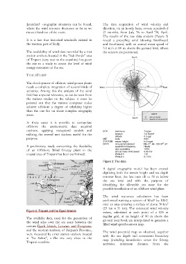
‡standard·  orographic situations can be found,   The  data acquisition of wind velocity and
                  where the wind resource decreases as far as we   direction, on an hourly basis, covers a period of
                  move inland out of the coast.                    21 months, from July '96 to April '98,  April.
                                                                   The results of the raw data analysis (Figure 3)
                  It  is  a  fact that historical windmills existed in   reveal  a  prevailing wind blowing Northward
                  the western part of Sicily.                      and Southward, with an annual mean speed of
                                                                   5.0 m/s at 10 m. above the ground level, where
                  The availability of wind data recorded by a met   the sensors are positioned.
                  station onshore located in the "Salt Ponds" area                   North
                  of Trapani (very near to the coastline) has given
                  the cue to a study to assess the level of wind                     20
                  energy resources on the sea.

                  THE STUDY                                                          10

                  The development of offshore wind power plants
                  needs a complete integration of several kinds of   West             0        10%     20% East
                                                                                       0      10     20
                  activities. Among this the analysis of the wind
                  field has a special relevance, as can be seen from
                  the  various studies on the subject. It must be
                  pointed  out that the various computer codes
                  achieve offshore a degree of reliability higher
                  than the one for on shore complex orography
                  areas.                                                                                 Legend
                                                                                      South      wind speed [m/s]
                                                                                                 frequency of occurrence [%]
                  In these cases it is possible  to  extrapolate
                  offshore the anemometric data acquired
                  onshore, applying recognised models and          SITE    commune           Trapani
                  utilising the several met stations useful for the        location          "Le Saline"
                                                                                             0 m agl
                                                                           altitude
                  purpose.                                         MET     code              0027
                                                                   STATION  sensor height    h=0 mast
                                                                                                 st
                                                                                                         st
                                                                   DATA    time period selected   Nov 1 , 96 - Oct 31 , 97
                  A preliminary study concerning the feasibility           acquisition frequency   Hourly
                  of  an  Offshore Wind Energy plant in the                data availability   100%
                                                                           annual mean wind speed
                                                                                             5.03 m/s
                  coastal area of Trapani has been performed.              Weibull k         1.61
                                                                           Weibull c         5.7 m/s
                                                                   Figure 3: The data
                                                                   A  digital orographic model has been created
                                                                   digitizing both the terrain height and sea depth
                                                                   contour lines, the last ones till to 50 m below
                                                                   the  sea level and with the purpose of
                                                                   identifying the allowable sea  zone  for  the
                                                                   possible installation of an offshore wind plant.


                                                                   The  wind  resources calculation has been
                                                                   performed running a session of WasP by RIS±
                                                                   over an area covering a surface of about 70 km 2
                                                                   (23 km x 31 km). The estimated wind velocity
                  Figure 2: Trapani and the Egadi Islands
                                                                   values, calculated at each point of  a  125  m
                                                                   regular grid, at an height of 80 m  above  the
                  The  available  data,  used for the generation of   ground (sea) level, are interpolated to generate a
                  the wind atlas over the  sea  zone  between  the
                  eastern  Egadi  Islands, Levanzo and Favignana,   filled wind speed contour map.
                  and the western territory of Trapani's Province,   The wind potential map so obtained,  together
                  were measured by a met station onshore located   with  the  sea depth and constraints boundary
                  at  "Le  Saline",  a  flat site very close to the   map (including interdiction zones  for  fishing
                  Trapani coastline.
                                                                   activities,  minimum  distance  from   the
   1   2   3   4   5   6