
Page 4 - EAI-4_2015_69-75
P. 4
Research & development
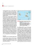
minimising potentially adverse activities. Within this FIGURE 1 Map of the Marine Protected Area of Egadi Islands,
context, ENEA aims to develop and realize actions for ^P[OHUPUKPJH[PVUVM[OLKPɈLYLU[aVULZ()*HUK+
sustainable tourism. By popularizing marine biological of protection
and environmental special features, knowledge will be :V\YJL!((== ¸9LSHaPVULÄUHSL(UHSPZP
increased thus generating further awareness among e valutazione dello stato degli ecosistemi marini
residents and nearby populations and visitors, making KLSSLaVUL(L)PU(YLL4HYPUL7YV[L[[LHUJOLHSÄUL
the marine resources more easy to protect against non- KP]HS\[HYLS»LɉJHJPHKLSSLTPZ\YLKPNLZ[PVUL
sustainable tourism. delle stesse”, CoNISMa e Ministero dell’Ambiente
Among the special underwater features of the Egadi e della Tutela del Territorio e del Mare
Islands, Posidonia oceanica meadows, included in
the Habitat Directive (43/92/CEE), are one of the The archipelago includes an area of high natural-
most important biocoenoses for their abundance and environmental interest, in particular the underwater
distribution all around the shallow seabed of the islands environment has a high biodiversity due to its particular
(~7.700 ha). In addition, on the deep rocky outcrops geographical position and hydrological conditions.
and shoals, the coralligenous community represents a Moreover, the coastal and underwater geomorphology
Mediterranean habitat of high ecological importance. shows peculiar features deserving protection. The
For its richness of species, the coralligenous community seabed morphology of the inner continental shelf is
is well known both by fishermen, who have eligible characterized by the presence of topographical highs
sites for fishing on coastal and offshore rocky shoals, and submarine valleys as the results of tectonics,
and by diving centres that often promote their activities Holocene eustatic sea-level changes, subaerial (during
in these habitats. However, the biodiversity associated Holocene high stand phases) and marine erosion
with the coralligenous community and its landscape processes [1, 2]. These processes are very active and
value, as well as the presence of species of aesthetic and influential around Egadi Islands where the sea currents
conservation interest are not well known from either a are very high,especially along the submarine valleys [3].
scientific point of view or by the resident population. The submerged caves and other topographical features
Here, we present the project carried out by some caused by intense erosion mechanisms following storms
researchers of the Marine Environment Research Centre and strong seabed currents are one of the most peculiar
(La Spezia, Italy) of ENEA aimed to realize actions for aspects that characterise the coastal area and the seabed
disseminating the knowledge on coralligenous and of Egadi Islands. Around the archipelago there are
marine coastal rocky communities characterizing several submerged rocky outcrops and wave-cut terraces
underwater habitats at Egadi Islands. The ultimate generally limited by faults, with almost vertical sides and
purpose of the work was to protect biological and shaped by hydrodynamics [4]. Those morphologies are
environmental resources, promote awareness of the
value of marine biodiversity among residents and
encourage sustainable tourism around Egadi Islands.
Study area:
The Marine Protected Area (MPA) of Egadi Islands
The Egadi archipelago, located a few km far from the
west coast of Sicily, comprises three main islands,
Favignana, Levanzo and Marettimo, and some minor
islands (Formica and Maraone); at present it is the
largest MPA in the Mediterranean, covering around 54
thousand hectares (Figure 1).
70 EAI Energia, Ambiente e Innovazione 4/2015