
Page 7 - Lodolo_Ben-Avraham_2015
P. 7
404 E. Lodolo, Z. Ben-Avraham / Journal of Archaeological Science: Reports 3 (2015) 398–407
monolith. It is however reasonable to assume that the PVB represented Table 1
an important line of communication with the interior, because located Radiocarbon dating results for the calcirudite samples.
midway between Sicily and Tunisia. Sample Water δ C Fraction Error D C Error 14 C calibrated Error
13
14
In the absence of finds of datable artefacts in the investigated area, n° depth modern ± ± years B.P. ±
we used the post-glacial curve of sea-level change for the Italian coasts (2SD)
to derive the latest date for the monolith and the term of human activ- 1A 38 m 0 0.0039 0.0006 −996.1 0.6 44,560 1270
ities in the PVB. We are fully aware however, that a considerable debate 2 36 m 0 0.0058 0.0006 −992.2 0.6 43,895 490
3 41 m 0 0.0100 0.0006 −990.0 0.6 36,960 500
has developed on the appropriate use and application of global curves
6A 35 m 0 0.0054 0.0006 −994.6 0.6 41,970 920
for regional cases, and an abundant literature was produced in recent
years on the spatial inhomogeneity in sea-level rise in different physio-
graphic and tectonic context (e.g., Milne and Mitrovica, 2008).
The curve of change in sea level is the combined result of (a) eustasy,
(b) glacial-hydro-isostasy, and (c) vertical tectonic motion. The first et al., 2009), as also confirmed by independent measurements derived
contribution to the sea-level change curve is global and time- from semi-permanent GPS stations (Serpelloni et al., 2005). The lack
dependent, while the latter two vary with location. Along the Italian of MIS 5.5 markers on the south-western shore of Sicily instead prevents
coasts, the glacio-hydro-isostatic component has been predicted and a proper determination of the vertical movement rate in this sector. Be-
compared with field data at several coastal sites (Lambeck and Purcell, cause the Adventure Plateau, where the PVB is rooted, is part of the
2005). The tectonic contribution is derived from the elevation of the same geological province of the western Sicily, the contribution of the
Marine Isotope Substage (MIS) 5.5 shoreline-marker, aged at vertical motion which has to be introduced for deriving age uncer-
124.5 k year (coinciding with the last interglacial), and its geochronolo- tainties should be the same as that calculated for the western sector of
gy is based on orbital tuning of high-resolution deep-sea oxygen isotope Sicily (±0.04 mm/year).
stratigraphy (Shackleton et al., 2003). During this last interglacial peri- The corresponding age, along with estimated errors, obtained by
od, the global sea level rose to a level higher than the modern sea intercepting the post-glacial sea-level curve with the present-day
level (Siddall et al., 2003). Along the Italian coasts, the average level water depths of the outer ridge summit (ranging from 35.1 to
attained by the sea during the MIS 5.5 is inferred to be of ~+7 m 36.8 m) is 9350 ± 200 year B.P. (Fig. 7). Thechoiceofthedepthof
(Lambeck and Purcell, 2005). Markers attributed to the last interglacial the top of the outer ridge is motivated because this morphological
are represented by notches, marine terraces, beach deposits, relief may have acted as a natural containment dam against the pro-
speleothem concretions and boreholes of molluscs living in the rocky gressive flooding of the inner land. We would have obviously got an
cliffs. The MIS 5.5 was used as a benchmark to assess tectonic stability older age for the monolith by applying the present-day depth of the
at individual coastal sites in Italy (Ferranti et al., 2006). sea-floor on which it lies. The obtained age falls chronologically
Analyses of geomorphological markers indicate that the western within the beginning of the Mesolithic period of the SE Europe and
sector of Sicily and Egadi Islands is tectonically stable (the calculated Middle East.
vertical tectonic rate is ±0.04 mm/year), at least for the period of the Age errors estimates for sites within the Italian Peninsula are given
Late Pleistocene and the Holocene (Ferranti et al., 2006; Antonioli by the following function (spatially averaged data), which provides an
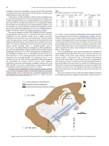
Fig. 6. Geological map of part of the PVB, produced on the basis of petrographic analyses of rock samples, divers inspections and detailed morphological mapping.