
Page 4 - Lodolo_Ben-Avraham_2015
P. 4
E. Lodolo, Z. Ben-Avraham / Journal of Archaeological Science: Reports 3 (2015) 398–407 401
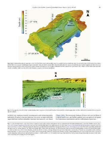
Fig. 2. High-resolution bathymetric map of part of the PVB. The 820 m long rectilinear ridge, as well as a parallel, but less continuous ridge, are seen on the map. To the north of these ridges,
at least three semi-circular morphological ridges (concentric rings) are visible: the monolith is located within this area. Areas surrounded by black dashed segments are those where un-
derwater surveys by divers were conducted. Numbers indicate the locations of rock samples collected in the PVB, some of them presented in Fig. 5. Black numbers refer to the Late Pleis-
tocene calcirudites; white numbers refer to the Tortonian calcareous mudstones-sandstones.
Fig. 3. 3-D perspective view of the high-resolution bathymetric map where the monolith has been discovered. No vertical exaggeration. Numbers indicate the locations of the correspond-
ing rock samples.
cements (e.g., meniscus cement) crossing pores and connecting grains, (Flügel, 2009). The microscopic features of these rocks are not those of
indicative of vadose-zone precipitation (as occurs in high-intertidal, a typical beach-rock, and further analyses are in progress to recognize
supra-tidal and shallow-subsurface meteoric environment), are absent the depositional environment and the sedimentation processes.
Fig. 1. (a) Morpho-bathymetric map of the Sicilian Channel and surrounding regions. Bathymetric data are taken from the International Bathymetric Chart of the Mediterranean (http://
www.ngdc.noaa.gov/mgg/ibcm/ibcm.html), and from the CIESM/IFREMER map of the Mediterranean sea-floor (http://www.ciesm.org/marine/morphomap.htm), integrated with data
taken from Civile et al. (2010), whereas topographic elevations are taken from the Shuttle Radar Topography Mission (http://www2.jpl.nasa.gov/srtm). Box in the upper left corner locates
the study area (SC: Sicilian Channel). AP: Adventure Plateau; MVC: Mazara del Vallo Channel; (b) Reconstruction of the Sicilian and Tunisian palaeo-shorelines at two different stages:
(1) when sea level was ~120 m lower than the present-day (brown contour), corresponding to the Last Glacial Maximum, the Adventure Plateau was connected to Sicily, forming a
broad peninsula; (2) when sea level was ~50 m lower than the present-day (dark grey contour), the formerly emerged islands (indicated in the map as small black areas) constituted
a wide archipelago between Sicily and the Pantelleria Island (~10,500 year B.P.). (c) 3-D shaded-relief map of the Pantelleria Vecchia Bank obtained from high-resolution swath bathy-
metric soundings performed by the R/V OGS-Explora.