
Page 7 - Pretto_Celesti_2012
P. 7
2564 F. Pretto et al.
The islands were digitized into a spatially refer-
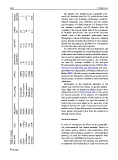
Resident population 1 77 11,275 0 6,444 enced GIS database (ArcGis 9.3), which allowed us to
directly derive the following explanatory variables:
latitude, longitude, area, perimeter and two widely
used measures of island isolation: (1) distance from
Altitude (m) 408 212 90 17 211 the mainland coastline and (2) distance from the
coastline of the nearest island. Indeed, the assessment
of isolation should take into account the fact that
islands close to the mainland, particularly those
belonging to a dense archipelago, may act as stepping
(km 2 ) stones, thereby reducing the isolation of more distant
islands and increasing the likelihood of colonization
Area 51.57 15.82 20.15 1.20 50.89 for both non-native and native species.
We inferred the intensity of human disturbance and
current land management by calculating the percentage
from (km) of the area of each island occupied by artificial surfaces,
that covered by agricultural surfaces and that subjected
Distance mainland 1.83 1.16 1.46 0.54 5.82 to environmental protection measures. As a baseline,
we used the overlays available at the European
Environmental Agency website (version 13/2010; http:
//www.eea.europa.eu/data-and-maps/data/) and inclu-
ded within the Italian project GIS Natura (Politecnico di
Latitude 4545155 4562205 4564710 4536296 4332638 Milano 2005). The latter project was also adopted as the
source of the lithological overlay that we used to define
the percentage of volcanic substratum and sedimentary
substratum.
Information on the maximum elevation of the
lithology types intrusive intrusive Metamorphic types islands was derived from atlases or specific publica-
tions, while data on human population density were
obtained from ISTAT (http://www.istat.it). As a proxy
Main Several Volcanic Volcanic Several for tourism pressure, in the absence of comparable
data on the receptive capacity of the islands or on the
annual number of visitors, we used the number of
ferries that reach each island on the same day at the
Administrative region Sardinia Sardinia Sardinia Sardinia Sardinia parable in size, this number provides a measure of how
height of summer (15 July). As most ferries are com-
many people and goods arrive from the mainland in
the peak tourist season.
Statistical analysis
Code ASIN CAPR_S LAMA ISOL SANP In order to investigate the effects of the geographi-
cal, environmental and human-mediated factors on
non-native species richness and composition, both
cotinued including and excluding casuals (i.e. not-established
species), we used two nested species datasets: total
1 name Maddalena Piana Pietro non-native and established non-native species.
Table Island Asinara Caprera La Isola San to determine the relationship of total non-native and
Univariate regression tree analysis was performed
123