
Page 6 - 31 antonioli PAG 8-11
P. 6
Climex Maps - explanatory notes
model., all calibrated with the same method the interval 5.9 - 11 ka cal. BP" from Lambeck et
(Bard, 1998) and studied on stable coastline
(with the exception of Sybari and del Volturno al., 2004.
sites). The 8 ka shorelines on the whole 4 Fondi. The Fondi Plain is a small coastal plain
important delta coastal area was corrected on bordered by limestone relief, with outcroppings of
the basis of the presence of cores radiocarbon
data (see numbers on the map). As regard the Pleistocene and Holocene alluvial, aeolian,
20 ka shorelines it is important to underline lagoon, and marine deposits.Samples containing
that are not published observed data to confirm Cerastoderma at -1.8 m previously gave an 14C
the predicted data by Lambeck that we used.
Such methodology is subject to error bars
(model and 14C ages) the positioning of the
shorelines marked on the maps are intended as
a first approximation.
The more complete the data set has been
sampled on numerous cores in the northern
Adriatic sea (Correggiari et al., 1997). Twenty-
seven dates from 60 continuously-cored
boreholes drilled in the subsurface of
southeastern Po Plain provide the basis for
detailed reconstruction of coastal
paleogeography at 8 ka cal BP (Amorosi et al.,
1999; 2003; in press). Data sampled on cores
on Versilia, Cagliari and Sibari Plain was very
useful for test and refine the Lambeck's model
for Italy.
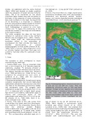
2. Data
The numbers in bold correspond to those Fig.2a Palaeogeographic reconstructions at
marked into the HCO map. 8 and 20 ka cal BP for Italy. The red
1 Versilia ENEA core. It is an important data (negative) contours refer to the sea level
set: a core crossed 34 m of Holocene lagoonal change. Palaeo water depths are indicated
sediments, sixsteen 14C analyses allowed to by the change in shades of blue at depths of
built a precise Italian Holocene sea level curve. 25, 50, 100, 150 and 200 m. The ice-
Two papers describe this stable site: Antonioli volume-equivalent sea level (esl) value are
et al., 1999 and Nisi et al., 2004. On fig. 1 are given in meters (from Lambeck et al.,
compared the predicetd sea level curve of 2004).
Lambeck et al., 2004, with the observed
lagoonal radiocarbon data. age of about 7.5 ka cal. BP (Antonioli et al.,
2 Argentarola speleothems. Sampling and aging 1988). More recently a continuously cored
serpulids overgrowths that coverd submerged borehole was drilled (Devoti et al., 2004;
speleothems allowed to reconscrutct a sea level Lambeck et al., 2004) near the outcrops that
rise data at the Argentario promontory during intersected marine sediments that filled a palaeo-
last semiglacial cycle. The samples were valley carved during the LGM, at about 0.75 km
collected by scuba diving at depths from 3.5 to inland from the present-day shoreline (N
21.7 m measured with a digital depth gauge 41°18'12'' - EGw 13°17'24''). The core was
Age control is provided by radiocarbon ages on detailed with sedimentological and micro-
marine and continental layers of the
speleothems and range from 6.5 to 9.6 ka cal.
BP (Alessio et al., 1992,1996; Bard et al.,
2002; Antonioli et al., 2004.
3 Roma. "The data at this site comes from
cores drilled 2 km apart, east from the present-
day coastline of the prograding Tevere Plain
near the silted-up ancient Roman
harbour.Belluomini et al. (1986) used sea-level
markers consisting of 14C-dated peat, marsh
and wood fragments found between –3 and –31
m. The corresponding calibrated ages are in