
Page 7 - 31 antonioli PAG 8-11
P. 7
Climex Maps - explanatory notes
palaeontological analysis; moreover, eleven core are given by Barra et al. (1996) and the
biomarker samples (8 shell fragments, 1 peat calibrated ages span the interval from 4.8 ka at –
sample, 1 Cerastoderma glaucum valve and 1 3 m to 7.4 ka BP at -8 m " from Lambeck et al.,
fragment of C. caespitosa) were collected for 2004.
chronology with 14C AMS dating. The dated 6 Palinuro Promontory.The analyses on serpulids
samples were correlated with backshore overgrowths that coverd submerged speleothems
deposits and shallow marine environment in sea caves at Palinuro promontory allowed to
reconscruct the sea level rise data at Palinuro
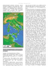
Fig.2b Palaeogeographic reconstructions promontory during Holocene. The samples were
at 20 ka cal BP for Italy (from Lambeck et collected by scuba diving at depths from -18 to -
al., 2004). 49 m measured with a digital depth gauge
deposits; the palaeobathimetry of these Speleothems from the Scaletta cave were
samples may be estimated at about +2/-4 m. sampled at depths between 27 and 48 m and
Marine shells between -3 and –33.7 m yielded yielded ages from 8.4 to 10.2 ka cal. BP (Alessio
calibrated ages in the interval 7.4 – 8.6 ka cal et al., 1992,1996, Antonioli & Oliverio 1996).
BP. 7 Catania Plain. A stratigraphic and sedimento-
5 Volturno Plain. "The Volturno River coastal logical study, accompanied by 14C AMS dating,
plain formed during the Holocene as a complex has been carried out by means of three boreholes
of beach-ridges and flat back-barrier in the most depressed coastal sector of the
depressions Catania Plain, the Pantano di Lentini. The
with lagoonal sedimentation. Lagoonal facies boreholes showed that clear lagoon deposits,
have been found in a core located at 2.5 km constituted by dark organic silts, are present only
from the present beach over a depth range of in the upper 2-3 m. Moreover, 14C AMS dating
10 m. Radiocarbon ages of peats found in this on pulmonate gastropod indicated an age not
older than 2.5 ka for these deposits. The
remaining sediments, down to the Lower-Middle
Pleistocene marly clayey substratum reached at
depths variable between -20 and -39 m, are
represented by infralitoral beach deposits
containing rare lagoon levels. The 14C AMS dating
on shell fragments collected at various depths
suggested an Holocene age, between 6.4 and 9.3
ka, for these deposits (Monaco et al., 2004).
8 Sybari Plain. "Archaeological excavations on
the Sybari alluvial plain have led to the
identification of three superimposed levels of
occupancy from the 6th to the 1st century BC: the
ancient Greek town of Sybaris, the Hellenistic
town of Thurium, and the Roman Copia. This
plain forms a graben that runs in an ENE-WSW
direction, bordered by regional fault systems.
The upper part of this depression is filled with ~
400 m of deposits consisting of sands including
fine clay-sands, coarse gravels and peat levels at
various depth. A core from the plain yielded 14C-
based ages in the interval 5.3 to 11.1 ka cal. BP
for peats and marsh deposits from depths of 3 to
55 meters below sea level (Cherubini et al.,
2000)", from Lambeck et al., 2004.
9 North Adriatic. "The northern part of the
Adriatic Sea is characterised by a shallow sea-
bottom morphology (at 30-50 m depth) with
sediments deposited by the Po River in the
immediate offshore area. The low shelf gradient
and the lower sediment input near the central
part of the basin results in significant landward
shifts of depositional environments at times of
sea-level rise. In consequence, successive
backstepping sequences do not completely
overlap. Furthermore, transgressive deposits are
not always covered by younger highstand