
Page 4 - EAI-4_2015_60-68
P. 4
the Mediterranean sea level, may
induce an intensification of the
erosion rate of the Sicilian high
coastal areas [4].
Some of the most popular places
of Favignana Island are bays
characterised by cliffs overlooking
an astonishing sea.Rock falls along
the cliffs are common and involve
the underlying beaches. The low
human activity in these areas Research & development
actually reduces the risk condition
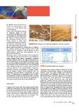
that remains concentrated during FIGURE 1 Bivalves (left) and cross-bedded layers (right) in the calcareous sandstones
the long warm season of the year,
when tourist frequentation is considerable. In addition,
the quarries opened in some of these bays, locally
called “pirrere”, constitute a cultural heritage of great
anthropological value that, once destroyed, can no
longer be reconstructed.
This paper reports a brief description of the investigation
on the cliffs and quarries of the eastern coast of Favignana
Island (western Sicily) where a quaternary calcareous
sandstone diffusely outcrops. The cliffs monitoring and the
slope movements assessment carried out during the study
are aimed to identify the most active areas.The study results
may contribute to the mitigation of the geomorphological
risk in Favignana Island and greatly support the local TABLE 1 Geotechnical characters of calcarenites
authorities’ policies in the implementation of mitigation
measures. Given the characteristics of the sites, inserted Favignana Island mainly consists of Mesozoic-Tertiary
into the largest European marine protected area, the carbonates unconformably overlain by Middle-Upper
intervention measures must be characterized by a high Pliocene marls and shales followed by Pleistocene
degree of environmental sustainability. If valid, effective biocalcarenites and Tyrrhenian calcarenites [5,6,7]. The
and sustainable measures are taken in the future, operators Mesozoic-Tertiary carbonates outcrop in the western
and users of the tourist circuit will have the opportunity to and central part of the island. The lower Pleistocene
enjoy these amazing areas with a lower landslide risk. biocalcarenites outcrop in the eastern part of the island,
generating a wide flat plate with nearly horizontal layers. In
Study area literature,itsthicknessranges between5and35m[8],though
a quarry in the inner part of Cala Rossa (“Niuro vecchio”and
“Niuro nuovo” caves) shows a vertical development of more
Favignana is the largest of the Egadi Islands, located off the than 50 m entirely in the calcarenites.The facies association
northwestcoastofSicily,nearthecitiesofTrapaniandMarsala. suggests different depositional environments (Figure 1) from
It extends for approximately 19 km2 and is surrounded by a the nearshore-beach zone (close to the Mt. Santa Caterina)
33 km of indented and mainly rocky coastline, marked by to the shoreface zone (in the eastern part of the Island).The
natural and anthropic cavities. The island is mostly flat, Middle-Upper Pliocene marls and shale locally outcrop
except for the mountain ridge that runs through it from between the base of the calcarenite cliffs and the sea
north to south (M.te Santa Caterina, 314 m a.s.l.). surface,partially hidden by a significant boulders deposit.
61EAI Energia, Ambiente e Innovazione 4/2015