
Page 6 - EAI-4_2015_60-68
P. 6
millimeter (tenths of millimeter Research & development
for the tell-tales). Overall 70
mechanical joint-meters were
installed,distributed along the cliffs
overlooking the sea of the three
bays and also within the numerous
cavities that open inside the cliffs.
The indirect measurements were
carried out through Terrestrial
Laser Scanner and GPS instruments.
While this latter allowed to
monitoring displacements of single
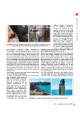
FIGURE 3 3D joint meter installed on the giant joint of the plateaux of the west side of Cala points located at the edge of the cliff,
Rossa (left) and the removable deformeter during the measurement survey the former acquired information
about a cloud constituted by
stereographic projection (lower hemisphere). millions of points representative of the whole vertical face
Furthermore, the mechanical features of the rock of the cliffs highlighted by the laser beam.
mass, including the mineralogical characteristics and Laser scanner survey [17] were performed using a laser
the rock compressive strength, were assessed with scanner (Riegl Z360) integrated with a high resolution
field instruments (Schmidt Hammer sclerometer) and digital camera (Nikon D100; Figure 4). Two Laser
laboratory experiments (thin sections, point load test, Scanner acquisitions (October 2012 an October 2013)
etc.).On the basis of the geological and geomechanical were performed in all the three bays, positioning the
features, the values of Beniawsky/Romana (RMR/SMR) instrument in four stations in Cala Rossa, four in Cala
and Sicily Region classifications [16] were assigned to del Bue Marino and five in Cala Azzurra. In order to
each station.The latter proposes a simplified approach compare subsequent temporal scanning [18, 19] and
generating an aggregate of some geomorphological, re-calibrate the instrument with a precision of mm,
environmental and historical parameters with the eight fix targets and ten mobile targets around the scan
mechanical characteristics typical of the traditional points (scanpositions) were materialized as a Cartesian
classification. coordinates system.
The monitoring activity was performed through the use The GPS monitoring techniques was applied only in
of direct and indirect instruments. Cala Rossa with the aim of identifying the movement
A direct measurements systems was implemented of single points along the cliffs with high accuracy.
with mechanical joints gauges of
different kind (tell-tale, removable
joint-meters, 3D joint-meters;
Figure 3) in relationship with the
different characteristics of the
walls, discontinuities and types of
movement to be recognised (one-
dimensional or three-dimensional).
These three mechanical join-
meters systems allow to measure
relative displacements between
two reference pins or two anchors
positioned across the joints with
a resolution of a hundredth of FIGURE 4 Laser scanner instruments during the acquisition survey in Cala Rossa
63EAI Energia, Ambiente e Innovazione 4/2015