
Page 5 - Grillini2015
P. 5
do not allow watercourses to form: only during some
violent storm, accompanied by heavy downpours,
small brooks form in some valley of the ridge, that
dry up in a few hours.
The survey
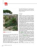
FIGURE 4 A typical quarry of “tufo” In the field
In order to characterize and monitor the groundwater
several quarries and caves pierce everywhere the of Favignana, two surveys were carried out in 2012,
terrain, giving the landscape its characteristic rough measuring the water table from selected wells with a
appearance (Figure 4). phreatimeter, main physical and chemical parameters
These calcarenite outcrops are not uniform, showing (pH, temperature, electrical conductivity, dissolved
cross and parallel bedding. They are also commonly oxygen, redox potential) with a multi-parametric probe,
alternated with lenses and thin beds of sands and and collecting water samples for further determination
conglomerates. From this it ensues that the groundwater of major cations, anions, and trace elements at the
in this sector is actually not hosted in a single, large environmental biogeochemical laboratory of the ENEA
aquifer, but in a group of small aquifers, some in Casaccia Research Centre.
hydraulic continuity some isolated. The monitoring was not targeted at the effective
The scarcity of rainfall, the calcareous nature of the potability of groundwater in a strict (and legal) sense: a
relief, and the limited extension of the island itself rather different approach should have been necessary,
planning biological analyses too, and a different and
more complex handling of the samples, from their
sampling to storing and analyzing. The chemical
results of this survey, instead, were intended primarily
to characterize the groundwater in terms of their salt
content: the first step was to differentiate the waters of
the various island zones, and locate the best tapping
spots (if possible and suitable).
With a preliminary investigation on the island, together
with Favignana municipal officials, 22 wells were
selected for their practical accessibility, among the
520 registered on the whole island: 7 in the western
sector, 4 in the eastern sector, and 11 in the urban area,
in the center of Favignana. While almost each of them
was open, and directly accessible with the measuring
instruments, in some cases it was only possible to get
from a tap the samples for the analyses.
Through a topographic survey performed with a DGPS
equipment (Figure 5), reference ground elevations
have been fixed for each site, in order to measure the
elevation above sea level of the groundwater table all
over the island, and its variation from one season of the
year to another.
The two seasonal campaigns were performed
22 EAI Energia, Ambiente e Innovazione 4/2015