
Page 10 - Seismogenic_evidence_2007
P. 10
06 133-20 06(209-222) 25-06-2007 14:24 Pagina 218
218 G. LAVECCHIA ET ALII
Intra-Apennine
a Adriatic
Basal extensional province Compressional province
Thrust D S
Seismogenic
Province (1741, 1799, 1873, (1672, 1690, 1786, 1875,
1897, 1943, 1950) 1916, 1924, 1930)
SW Umbria-Marche coast NE
S fold-and-thrust system
0
D
10
20 Adriatic basal thrust
km
0 km 40 10 km MOHO
25 km 40 0 km 20
Nebrodi-Peloritani.
extensional
province Compressional province
D S
b
(361, 1818,1968) (1624)
coast
25 NNE N coast Panormide-Imerese S
thrust system
km
0 0
10 km
10 10
S D
Sicilian S 20 20 Sicilian basal thrust
Basal AL
Thrust zone km km MOHO
Seismogenic
Province 0 km 40
40 40 0 km 20
(.... 1818,.....)
1 2 3 4 5 6 7 8 9
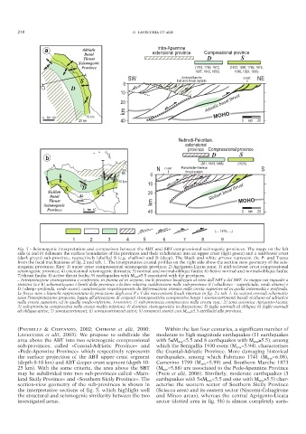
Fig. 5 - Seismogenic interpretation and comparison between the ABT and SBT compressional seimogenic provinces. The maps on the left
side (a and b) delineate the surface boundaries of the provinces and their subdivision into an upper crust (light green) and a mid-lower crust
(dark green) sub-province, respectively labelled S (e.g. shallow) and D (deep). The black and white arrows represent the P- and T-axes
from the focal mechanisms of fig. 2 and tab. 1. The interpretative crustal profiles on the right side show the section view geometry of the seis-
mogenic provinces. KEY: 1) upper crust compressional seismogenic province; 2) Agrigento-Licata zone; 3) mid-to-lower crust compressional
seismogenic province; 4) extensional seismogenic domains; 5) normal and normal-oblique faults; 6) Active normal and normal-oblique faults;
7) thrust faults; 8) active thrust faults; 9) earthquakes with M aw ≥5.5 associated with the provinces.
– Intrepretazione sismogenetica e confronto, in pianta ed in sezione, tra le province localizzate al tetto dell’ABT e del SBT. Le mappe nei riquadri a
sinistra (a e b) schematizzano i limiti delle province e la loro relativa suddivisione nelle sub-province S («shallow» - superficiale, verde chiaro) e
D («deep»-profonda, verde scuro), caratterizzate rispettivamente da deformazione sismica nella crosta superiore ed in quella intermedia e profonda.
Le frecce nere e bianche rappresentano la proiezione degli assi P e T dei meccanismi focali riportati in fig. 2 e tab. 1. Le sezioni crostali schematiz-
zano l’interpretazione proposta, legata all’attivazione di sorgenti sismogenetiche compressive lungo i sovrascorrimenti basali siciliano ed adriatico
nella crosta superiore ed in quella medio-inferiore. LEGENDA: 1) sub-provincia compressiva nella crosta sup.; 2) zona asismica Agrigento-Licata;
3) sub-provincia compressiva nella crosta medio-inferiore; 4) dominio sismogenetico in distensione; 5) faglie normali ed oblique; 6) faglie normali
ed oblique attive; 7) sovrascorrimenti; 8) sovrascorrimenti attivi; 9) terremoti storici con M aw ≥5.5 attribuiti alle province.
(PAUSELLI & COSTANZO, 2002; CHIRONI et alii, 2000; Within the last four centuries, a significant number of
LAVECCHIA et alii, 2003). We propose to subdivide the moderate to high magnitude earthquakes (11 earthquakes
area above the ABT into two seismogenic compressional with 5≤M aw <5.5 and 8 earthquakes with M aw ≥5.5), among
sub-provinces, called «Coastal-Adriatic Province» and which the Senigallia 1930 event (M aw =5.94), characterises
«Pede-Apennine Province» which respectively represents the Coastal-Adriatic Province. More damaging historical
the surface projection of the ABT upper crust segment earthquakes, among which Fabriano 1741 (M aw =6.08),
(depth 0-10 km) and ABT deeper crust segment (depth 10- Camerino 1799 (M aw =5.99) and Southern Marche 1873
25 km). With the same criteria, the area above the SBT (M aw =5.88) are associated to the Pede-Apennine Province
may be subdivided into two sub-provinces called «Main- (PACE et alii, 2006). Similarly, moderate earthquakes (3
land Sicily Province» and «Southern Sicily Province». The earthquakes with 5≤M aw <5.5 and one with M aw ≥5.5) char-
section-view geometry of the sub-provinces is shown in acterise the western sector of Southern Sicily Province
the interpretative sections of fig. 5, which highlight well (Sciacca area) and its eastern sector (Niscemi-Caltagirone
the structural and seismogenic similarity between the two and Mineo areas), whereas the central Agrigento-Licata
investigated areas. sector (dotted area in fig. 5b) is almost completely aseis-