Page 3 - Acoustical_underwater_2003
P. 3

Revue d'Archéométrie, 27, 2003                           39

                    ELECTROACOUS  IC  AND                                                   OUTPU T
                    MAG N ETIC  EQU I PMENT

                                                    POSITI O NIN G  S YST E,..1


                                                                                     Side Se an  S o nar lma g
                                                                           a t  ti i t es


                                                                                           ROV  Vid e o
                                                         DAT A  FLOW
                            R. OV


                                                 j
                        Gr ad i om e t e r
                                            DATA  ACQUI  I T ION
                                            UNI T
                                                                                          Ca rtogr a p h y
                                                                  DATA  PROCESSING
                                                                  UN l


                         M  lti  Bea                                              3D  Mu l ti Bea.m  E'l aborat ion
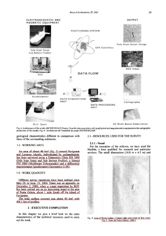
             Fig. 4: Architecture ofthe whole ARCHEOEGADI Project, from the data acquisition with geophysical and magnetometric equipment to the cartographic
             production ofthe results. Fig. 4: Architecture de l'ensemble du projet ARCHEOEGADI.
             geologica]  characteristics  different  in  comparison  with   2.1  - RESOURCES USED FOR THE SURVEY
             those of the surrounding sediments.
                                                                 2.1.1 - Vessel
             1.3 - WORKING AREA
                                                                 For  the  execution  of the  re1ieves,  we  have  used  the
                                                                MedMa,  a  boat  qualified  for  research  and  particu1ar
                                   2
               An  area  of about  40  km (fig.  3)  around  Favignana   services.  The  small  dimensions  (16.8  m  x  4.3  m)  and
             and  Levanzo  is1ands,  individuated  by  archaeo1ogists,
             has  been  surveyed  using  a  Datasonics Chirp  SIS  l 000
             (Side  Scan  Sonar  and  Sub  Bottom  Profi1er),  a  Simrad
             EM  3000  (Mu1tibeam  Echosounder)  and  a  differentia1
             magnetometer (gradiometer) Geometrics G-881.

             1.4 - WORK QUANTITY

              Offshore  survey  operations  have  been  rea1ised  since
             May  29,  to  June,  21,  2000. There  was  an  appendix  on
             December  2,  2000,  when  a  visual  inspection  by  ROV
             has been carried out on an interesting target in the area
             of Punta  Galera,  about  l  mile  South  off the  island  of
             Favignana.
                                                     2
              The  total  surface  covered  was  about  40  km with
             406.1  km of profiles.
                     2 - EXECUTIVE COMPLETION

              In  this  chapter  we  give  a  brief 1ook  on  the  main
             characteristics  of the  technica1  resources  used  to  carry
                                                                Fig.  5:  Area of Punta Galera:  I Target (side scan sonar on  line  view).
             out the work.                                                Fig. 5 : Zone de Punta Galera : cible I.
   1   2   3   4   5   6