Page 4 - Acoustical_underwater_2003
P. 4

40                                    Revue d'Arrhénmétrie. 27.  2003

                                                                above  all  draft  ( 1.2  m)  of the  boat pennitted  to  fit  out
                                                                the  instrumentation  and  to  operate  in  a  secure  way  to
                                                                completely cover the survey areas.

                                                                 2.1.2  - Acquisition  and  navigation  data integrated
                                                                system
                                                                 Digitai  data  acquisition  has been carried out with  an
                                                                integrated  system  based  on  a  Personal  Computer  and
                                                                managed by the acquisition/navigation SW HYDRQ® by
                                                                Trimble Navigation Ltd.
                                                                 This system pennits to define,  during the planning of
                                                                the mission, and therefore to execute all the procedures for
                                                                the management and the acquisition of the instrumental
                                                                data.  In  particular  it  defines  the  navigation  pian  and
                                                                gives all  the graphical and numerica! infonnation about
                                                                the vessel  commands; it also acquires and logs the data
                                                                measured  by  different  connected  sensors;  it  gives  both
                                                                sequential fix  of analog/digital records  and the position
                                                                of sensors, corrected on the basis of the relative offsets.

                                                                 2.1.3- Posilioning system
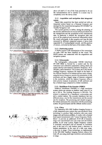
             Fig. 6: Area ofPunta Galera: l Target (side scan sonar). Fig. 6: Zone de   A DGPS receiver with transmission of the corrections
                            Punta Galera : cible l.             via  radio  VHF  has  been  installed  on  the  vessel.  The
                                                                DGPS  station  was  connected  with  the  acquisition  and
                                                                navigation system.

                                                                 2.1.4 - Echosounder
                                                                 The  hydrographic  echosounder  ODOM  EchoTrack
                                                                DF-3200  MKII  is  fonned  by  a  contro]  unit  for  the
                                                                instrument and calibration parameters setting (draft and
                                                               sound velocity) and measure (operative frequency:  24 or
                                                               200kHz), and a transducer. The system, due to the double
                                                               working  frequency,  measures the  depth  on  the  basis  of
                                                               the different fcatures ofthc bottom and sea water column:
                                                               using the lowest frequency pennits the penetration of silk
                                                               sediments and  has a bigger range of measure compared
                                                               to  the  resolution,  whilst  the  highest  frequency  offers  a
                                                               more  precise measure  in  presence of silk  sediment and
                                                               has a limited range compared to a better resolution.
                                                                 2.1.5- MultiBeam Echo-Sounder (MBES)
                                                                 SIMRAD  Multibeam  EM3000  is  a  high  resolution
                                                               system which can operate on shallow water since 0.5  m
                                                               up  to  200  m.  The  working  frequency  is  300  kHz.  The
             Fig. 7: Area of Punta Galera:  Il Target (side scan sonar). Fig. 7 :Zone
                           de Punta Galera: cible Il.          system  is  composed  by  a  transducer,  a processing  unit
                                                               and  a  contro}  station.  The  acoustic  transducer  has  two
                                                               different arrays, one for the transmission and the second
                                                               one for reception. The processing unit should recognise
                                                               the bottom and assure the connection with the positioning
                                                               system, the gyrocompass and thc attitude motion sensor.

                                                                 2.1.6 - Chirp
                                                                 The Datasonics SIS-1 000 Seafloor Imaging System is
                                                               a fully integrated sonar system that uses advanced Chirp
                                                               technology  to  produce  high  resolution  side  scan  sonar
                                                               images and sub bottom profilers.  lt works with a limited
                                                               band signal transmission with "Linear Frequency Modu-
                                                               lation",  to  provide  an  additional  20-30  dB  of dynamic
                                                               range over conventional side scan sonar and sub bottom
                                                               profiler.  In  ali  sonar  system,  higher  frequency  content
                                                               is  invariably  associatcd  with  an  increase  in  resolution
                                                               and,  in  the  case  of a  sub  bottom  sonar,  a  decrease  in
                                                               bottom  penetration;  in  the  case  of a  side  scan  sonar,
                                                               a decrease  in  range.  Chirp technology,  as  implemented
                                                               in  the  SIS-1 000' Seafloor lmaging  System reduces this
                                                               trade-off, providing both high resolution and penetration
            Fig. 8:  Area of Punta Galera:  III  Target (sub bottom profiler).  Fig.  8 :   or range.
                         Zone de Punta Galera : cible 111.
   1   2   3   4   5   6