
Page 6 - Acoustical_underwater_2003
P. 6
42 Re.vue. d'An:héométrie. 27. 2003
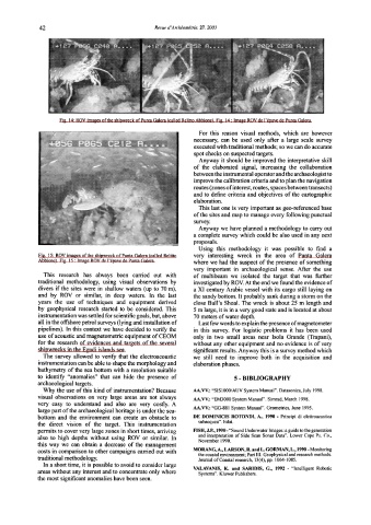
Fig. 14: ROV images ofthe shipwreck ofPunta Galera (called Relitto Abbione). Fig. 14: lmage ROV de l'épave de Punta Galera.
For this reason visual methods, which are however
necessary, can be used only after a large scale survey
executed with traditional methods; so we cando accurate
spot checks on suspected targets.
Anyway it should be improved the interpretative skill
of the elaborated signal, increasing the collaboration
between the instrumental operator and the archaeologist to
improve the calibration criteria and to pian the navigation
routes (zones of interest, routes, spaces between transects)
and to define criteria and objectives of the cartographic
elaboration.
This last one is very important as geo-referenced base
of the sites an d ma p t o manage every following punctual
survey.
Anyway we bave planned a methodology to carry out
a complete survey which could be also used in any next
proposals.
Using this methodology it was possible to find a
Fig. 15: ROV images ofthe shipwreck ofPunta Galera (called Relitto very interesting wreck in the area of Punta Galera
Abbione). Fig. 15 : lmage ROV de l'épave de Punta Galera.
where we had the suspect of the presence of something
very important in archaeological sense. After the use
This research has always been carried out with of multibeam we isolated the target that was further
traditional methodology, using visual observations by investigated by ROV. At the end we found the evidence of
divers if the sites were in shallow waters (up to 70 m), a XI century Arabic vessel with its cargo stilllaying on
and by ROV or similar, in deep waters. In the last the sandy bottom. lt probably sank during a storm on the
years the use of techniques and equipment derived close Bull 's Shoal. The wreck is about 25 m length and
by geophysical research started to be considered. This 5 m large, it is in a very good state and is located at about
instrumentation was setti ed for scientific goals, but, above 70 meters of water depth.
ali in the otfshore petrol surveys (lying and installation of Last few words to explain the presence of magnetometer
pipelines). In this context we have decided to verify the in this survey. For logistic problems it has been used
use of acoustic and magnetometric equipment of CEOM only in two small areas near Isola Grande (Trapani),
for the research of evidences and targets of the severa) without any other equipment and no evidence is of very
shipwrecks in the Egadi islands sea. significant results. Anyway this is a survey method which
The survey allowed to verify that the electroacoustic we stili need to improve both in the acquisition and
instrumentation can be able to shape the morphology and elaboration phases.
bathymetry of the sea bottom with a resolution suitable
to identify "anomalies" that can hide the presence of 5- BIBLIOGRAPHY
archaeological targets.
Why the use of this kind of instrumentation? Because AA.VV.: "SIS1000/AUV System Manua1". Datasonics, July 1998.
visual observations on very large areas are not always AA.VV.: "EM3000 System Manual". Simrad, March 1998.
very easy to understand and also are very costly. A
AA.VV.: "GG-881 System Manual". Geometrics, June 1995.
large part of the archaeological heritage is un der the sea-
bottom and the environment can create an obstacle to DE DOMINICIS ROTONDI, A., 1990 - Principi di elettroacustica
the direct vision of the target. This instrumentation subacquea". Edai.
permits to cover very large zones in short times, arriving FISH, J.P., 1990-"Sound Underwater lmages: a guide to the generation
and interpretation of Side Scan Sonar Data". Lower Cape Pu. Co.,
also to high depths without using ROV or similar. In
November 1990.
this way we can obtain a decrease of the management
costs in comparison to other campaigns carried out with MORANG,A., LARSON, R. and L. GORMAN, L., 1990- Monitoring
the coastal environment; Part III. Geophysical and research methods.
traditional methodology. Journal ofCoastal research, 13(4), pp. 1064-1085.
In a short time, it is possible to avoid to consider large
VALAVANIS, K. and SARIDIS, G., 1992 - "lntelligent Robotic
areas without any interest and to concentrate only where
Systems". Kluwer Publishers.
the most significant anomalies have been seen.