
Page 4 - EAI-4_2015_48-59
P. 4
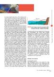
the closure depth of the site (i.e., the maximum water       FIGURE 2  ;`WPJHSMLH[\YLZVMJYVZZZOVYLILHJOWYVÄSLTVKLSSPUN      Research & development
depth of significant sediment transport, depending on                       Source: Exploring Florida. A Social Studies Resource
wave climate) is located within the headlands, long-                        for Students and Teachers, University of South Florida
shore sediment exchange is negligible. In this case, the
pocket beach can be regarded as a closed sediment            Sometimes, however, beach changes can be permanent
cell, where sediment supply to the beach is essentially      and non-reversible. This occurs when sediment
due to shoreward cliff erosion (if comprised of soft         supply from the backshore is reduced or interrupted,
rock), or stream discharge (if present).                     typically for man-induced causes as land-use change,
A large body of literature exists on the dynamics of pocket  modification of hydrographic network, sediment
beaches [3, 4, 5, 6, 7, 8]. As regards plan-view geometry,   extraction from riverbed, destruction of dunes,
a number of planform parameters and ratios are used in       construction of seawalls and other hard structures [15,
literature to describe and classify the coastal morphology   16, 17]. Other possible cases of barely reversible beach
and estimate the equilibrium status of the beach [9]. Due    changes can be due to sediment delivered by streams
to the limited sediment transport at ends, the coastline     during extreme flood events, as reported for the Elba
generally tends to align itself with prevailing incident     Island, [18, 19]. These are not the cases in Favignana,
wave fronts, assuming a typical seaward concave plan         given the absence of an organized river network.
shape that can be approximated by a logarithmic spiral or    In the framework of a wider research program, an
different mathematical functions. The resulting coastline    extensive investigation of coastal morphology and
configuration, corresponding to ideal conditions of          dynamics was performed at Cala Azzurra and Lido
stability, is a classical and appreciated conceptual         Burrone sites during the period 2012-2014. First
scheme for coastal stabilization projects. The coastline     results of the work, including an outline of materials
orientation – i.e. the orientation of the line connecting    and methods and partial data analysis, have been
the edges of the beach – is a typical parameter used to      synthetically presented in a previous paper [20].
empirically describe coastline adaptation to incident        Besides any scientific interest, the results of the projects
waves. In general, if coastline orientation is aligned with  will contribute to create a knowledge base aimed
the line connecting the headlands of the bay, a relative     to implement measures for sustainable tourism and
stability of the beach is to be expected, while coastline    management of marine resources.
rotation can be regarded as a morphological response to
changes in approach angles of prevailing incident waves.     Materials and methods
Assuming a substantial stability in terms of long-shore
sediment processes, the dynamics of a pocket beach           +\GURJUDSKLFVXUYH\V
is frequently dominated by cross-shore modelling of          Four hydrographic surveys were performed at Cala
beach profile. As well established in literature [10, 11,    Azzurra and Lido Burrone, in the following periods:
12], for a given profile geometry and sediment grain         November 2012 (Survey 1), July 2013 (Survey 2),
size,cross-shore modelling can result in beach accretion     September 2013 (Survey 3), and May 2014 (Survey 4).
or erosion depending on incident wave conditions. In         The temporal planning of surveys was defined in order to
case of high energy incident waves, offshore sediment
transport (destructive forces) prevails, resulting in
coastline retreat; on the contrary, with milder wave
activity, the onshore transport (constructive forces)
prevails and the result is a coastline advance (Figure
2). Cross-shore modelling processes are generally
reversible, and the effects are alternations between
two typical beach profile shapes, referred to as
“storm”,“winter” or “bar-type” profile, and “ordinary”,
“summer” or “berm-type” profile, respectively [13, 14].

                                                             49EAI Energia, Ambiente e Innovazione 4/2015