
Page 10 - Gerardini2012
P. 10
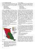
5. lavori precedenti                                          5. past works
La prima carta geologica dell’isola di Marettimo è sta-       The first geological map of the island of Marettimo
ta redatta nel 1996 da Abate, Incandela e Renda. Nella        was drafted in 1996 by Abate, Incandela and Ren-
carta sono evidenziate quattro unità tettoniche (Fig. 9):     da. In the map are shown four tectonic units (Fig. 9):

     - Punta Bassano;                                             - Punta Bassano;
     - Monte Falcone;                                             - Monte Falcone;
     - Punta Bombarda;                                            - Punta Bombarda;
     - Punta Troia-Marettimo.                                     - Punta Troia-Marettimo.

L’isola è caratterizzata da geometrie piane e                 The island is characterized by multiple thrust faults
sovrascorrimenti multipli in cui le prime tre unità           and planar geometries in which the first three units
si sovrappongono sull’ultima (Punta Troia-Maret-              are superimposed on the last (Punta Troia-Maret-
timo). Le unità sono molto simili tra loro, derivano          timo). The units are very similar, all derived from a
tutte da una successione di piattaforma carbonatica           sequence of Triassic-Liassic carbonate platform and
del Triassico-Liassico e con piccole differenze lito-         with slightly different lithology. In the NE sector, the
logiche. Nel settore NE, l’unità di Monte Falcone             Monte Falcone unit overriding the Punta Troia-
sovrascorre quella di Punta Troia-Marettimo lungo             Marettimo unit along a ramp with a very low angle.
una rampa a bassissimo angolo. Sono rappresentate             Also represented are many faults from unknown ki-
anche molte faglie dalla cinematica sconosciuta.              nematics. In the work mentioned above, there are
Nel lavoro sopra richiamato, si riscontrano diverse           several inconsistencies, briefly highlighted below:
incongruenze, sinteticamente sotto evidenziate:               - the geological sections do not coincide with the
- le sezioni geologiche presenti non coincidono                geometries shown in paper and the thicknesses de-
 con le geometrie rappresentate in carta e gli                 scribed in the stratigraphic logs;
 spessori descritti nei log stratigrafici;                    - the geological survey has revealed that many faults
- il rilevamento in situ ha rivelato che molte faglie
 e affioramenti non esistono;                                   and outcrops do not exist;
- l’unità di Monte Falcone ha una variabilità lito-           - Monte Falcone unit have a much wider lithological
 logica molto più ampia.                                       variability.

                                                              The current geological map of the island of Marettimo
                                                              is represented by Foglio 604 Egadi Islands (D’Angelo et
                                                              al., In press) that belongs to the C.A.R.G Project of the
                                                              Italian Geological Society, which sets out specific rules
                                                              on the definition of units (e.g. sequences, formations, syn-
                                                              thems,..etc.). In the study area outcrops n.5 units (Fig. 10):
                                                               - Sciacca formation (SIA);
                                                               - Enterolithic dolomites and bituminous marls

                                                                (DEM);
                                                               - Monte Falcone formation (MFA);
                                                               - Buccheri formation (BCH);
                                                               - Barcarello synthem.

Fig. 9 - Schema tettonico: Unità di Punta Bassano (Verde);    The units mentioned above are part of the succession
         Unità di Mt. Falcone (Rosso); Unità di Punta Troia-  Pre-Panormide or Quaternary deposits, whose de-
         Marettimo (Blu); Unità di Punta Bombarda (Rosa);     tailed descriptions are available in the stratigraphic
         (Abate et al., 1996).                                legend of the geological map (Foglio 604). The tec-
                                                              tonic scheme shows a system of three normal faults,
Fig. 9 - Tectonic Scheme: Punta Bassano Unit (Green); Mt.     parallel to the southern, western and eastern coast of
          Falcone Unit (Red); Punta Troia-Marettimo Unit      the island, which can be considered a horst (Fig. 11).
          (Blue); Punta Bombarda Unit (Pink);
          (Abate et al., 1996).

10