
Page 9 - Gerardini2012
P. 9
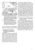
Fig. 8 - Schema tettonico dell’area del Mediterraneo centrale    4.2 thrusting (oligocene - miocene)
         (Catalano et al., 2001). 1) Blocco Sardo-Corso; 2)      From the Oligocene onwards, the entire area has been
         Arco Calabro, Kabilide e sequenza ofiolitica del flysh  subject to a compressional tectonic regime, as a result
         “interno”; 3) Nappe delle Magrebidi-Sicilidi-Appenni    of convergence between the African and European
         no Meridionale e l’avanpaese deformato; 4) Avanpaese    plates that produced the “fold and thrust belt” Sicil-
         leggermente piegato e avanpaese; 5) Aree soggette ad    ian-Magrebide (Nigro & Renda, 2005), which propa-
         estensione; 6) Vulcani Plio-Quaternari.                 gates towards S-SE (Catalano & D’Argenio, 1978;
                                                                 Catalano et al., 2000) (Fig. 8). From the interpreta-
Fig. 8 - Tectonic map of the central Mediterranean area          tion of seismic sections of the archipelago of the Egadi
         (Catalano et al., 2001). 1) Sardinia-Corsica block; 2)  Islands, it is clear that the units Panormidi and Pre-
         Calabrian arc, Kabylians and “Internal” Flysh se        Panormidi are partially overlapped with the previ-
         quence ophiolites; 3) Maghrebian-Sicilian-Southern      ous and adjacent carbonate platforms (units Imerese
         Apennine nappes and deformed foreland; 4) Foreland      and Saccense) (Catalano et al., 1996). Seismic lines of
         and mildly folded foreland; 5) Areas with superim       the internal Sicily indicate that Pre-Panormide nappes
         posed extension; 6) Plio-Quaternary volcanoes.          have maintained their structural coherence and lat-
                                                                 eral continuity, with bodies up to 1500 m thick and
la loro coerenza strutturale e continuità stratigrafi-           lateral extension up to 10 km (Catalano et al., 2001).
ca laterale, con corpi fino a 1500 m di spessore es-
tesi per decine di chilometri (Catalano et al., 2001).           4.3 low angle extension (upper miocene
                                                                     - lower pliocene) and transcurrent
4.3 Estensione a basso angolo                                        faulting (pliocene)
    (Miocene Sup. - Pliocene Inf.) e
    fagliamento trascorrente                                     From the Late Miocene onwards, the geometry of the
    (pliocene)                                                   thrust belt was strongly modified by extensional fault-
                                                                 ing and crustal thinning correlated with the develop-
Dall’ultima fase del Miocene in poi, la geometria del            ment of the Tyrrhenian Basin (Elter et al. 2003). This
“thrust belt” era profondamente modificata dal fa-               is mainly represented by normal faults with stepped
gliamento estensionale e dall’assottigliamento della             geometry, generally northwards dipping, towards the
crosta, causati dalla creazione del bacino Tirrenico             Tyrrhenian Sea (Nigro & Renda, 2005). The main
(Elter et al., 2003), costituito da faglie normali lis-          cause is attributed to the anticlockwise rotation of the
triche nord-immergenti (Nigro & Renda, 2005). Tutto              Sardinia-Corsica block and its successive collision with
ciò è stato causato dalla rotazione in senso anti-orario         the North African margin (Catalano et al. 1995). A
del blocco Sardo-Corso e la successiva collisione col            plio-pleistocenic transcurrent phase has also been rec-
margine Nord Africano (Catalano et al., 1995). Inol-             ognized (Abate et al., 1995; Nigro & Renda, 2005).
tre, è stata riconosciuta una fase trascorrente nel Plio-
Pleistocene (Abate et al., 1995; Nigro & Renda, 2005).

                                                                 9