Page 2 - Gueguen_alii_2002
P. 2

78                                           E. GUEGUEN ET ALII


                  10°               12°                14°               16°               18°
        42°                                                                                                  42°

                                                                              A
                                                        IT
                                          CAM
                                                                                D
                                      C  L       P                                 R
                                                   A
                                                                                     I
                                                      N      AL
                                                                                       A
                                                        I
                                                                                         T
                                                         A        Y                        IC

                     Baronie                                                                    S
                                                                L U C
                                                                             APULIA
                     Mts.                                              A  N                       E
                                                                            I                       A
                                                                             A
        40°                                                                                                  40°
                                    Vavilov      3000 m  2000 m  1000 m
                                                                               A
                                                                               I
                          TYRHENIAN
                                                    Marsili            Paola   R
             SARDINIA
                                  SEA                                  Basin
                                                                               B
                             U  E  L             U  E  L                      A
                2000 m          T F        Ustica                Eolie       A  L
                 1000 m      M F        S V F     P F        E F            C  1000 m
                                   Egadi
        38°                                                                                                  38°
                                                        *
                    oceanic                             K  A  L              2000 m
                    crust                       SICIL
                                                                                3000 m
                                                           Y                                         A
                     Apennine          transform                                                    E
                     front             faults                                                      S
                                                                                              N
                                                           S F          M E       I O N I A
                 main                extensional
                 volcanoes           faults
        36°                                                                                                   36°
                  10°               12°                14°               16°               18°
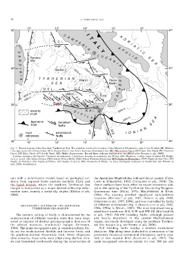
        Fig. 1 - Tectonic map of the Southen Tyrrhenian Sea. The asterisk marks the location of the Madonie Mountains, and of the Gratteri-Mt. Mufara
        Line (see text). CL) Circeo Line; UEL) Ustica-Eolie Line; KAL) Kumeta-Alcantara Line; MF) Marettimo Fault; SVF) San Vito Fault; PF) Palermo
        Fault; EF) Etna Fault, SF) Scicli Fault, ME) Malta Escarpment. Dotted lines indicate bathymetry (modified after RENDA et alii, 2000).
        – Schema tettonico del bacino Tirrenico meridionale. L’asterisco mostra la posizione dei Monti delle Madonie, e della Linea Gratteri-Mt Muffa-
        ra (c.f. testo). CL) Linea Circeo; UEL) Linea Ustica-Eolie; KAL) Linea Kumeta-Alcantara; MF) Faglia di Marettimo; SVF) Faglia di San Vito; PF)
        Faglia di Palermo; EF) Faglia dell’Etna, SF) Faglia di Scicli, ME) Scarpata di Malta. Le linee trattegiate indicano la batimetria (da RENDA et
        alii, 2000, modificato).


        tent with a deformation model, based on geological evi-  the Apennines-Maghrebides fold-and-thrust system (CATA-
        dence from exposed faults onshore northern Sicily and  LANO & D’ARGENIO, 1982; CATALANO et alii, 1984). The
        the Egadi Islands, where the southern Tyrrhenian Sea  thrust surfaces have been offset by recent structures rela-
        margin is interpreted as a major dextral strike-slip defor-  ted to the opening of the Tyrrhenian Sea during Neogene-
        mation zone, namely a strike-slip duplex (RENDA et alii,  Quaternary time (SELLI, 1974; MALINVERNO & RYAN,
        2000).                                                1986). The opening involved significant anticlockwise
                                                              rotations (REHAULT et alii, 1987; DEWEY et alii, 1989;
                                                              GUEGUEN et alii, 1997, 1998), and was controlled by faults
                                                              of different orientations (fig. 1; BOCCALETTI et alii, 1982,
               GEODYNAMIC SETTING OF THE SOUTHERN
                      TYRRHENIAN SEA MARGIN                   1984, 1990a, b; WEZEL, 1985). The most important recog-
                                                              nised fault trends are: N-S, E-W and NW-SE (BOCCALETTI
           The tectonic setting of Sicily is characterised by the  et alii, 1982). NE-SW trending faults, although present
        superposition of different tectonic units that were origi-  and locally important in the central Mediterranean
        nated at expense of distinct paleogeographic domains of  region, are poorly developed along the southern Tyrrhen-
        the african mesozoic continental margin (OGNIBEN,     ian Sea margin (e.g. see NIGRO et alii, 2000).
        1960). The main recognised units in central-northern Sic-  N-S trending faults display a marked extensional
        ily are the basin-derived Sicilide and Imerese Units, and  character. Slip along these faults led to attenuation of the
        the platform-derived Panormide Unit. From Oligocene   previously thickened continental lithosphere, and to crea-
        time onwards, these units were piled along shallow thru-  tion of new oceanic floor (KASTENS et alii, 1987). The
        sts and translated southwards during the construction of  main recognised structures extend for over 300 km and
   1   2   3   4   5   6   7