
Page 6 - Gueguen_alii_2002
P. 6
82 E. GUEGUEN ET ALII
a formed to obtain station coordinates on a daily basis. The
terrestrial reference frame has been strictly constrained
U E L U E L to ITRF96 fixing the position and the velocity of Wettzell
together with IGS precise orbits and related Earth orien-
tation parameters. The station velocities have been obtai-
ned estimating the linear slopes from the coordinate time
P F
M F
S V F
E F
N series. A more detailed description of the solution is avail-
* ? able in FERMI et alii (1997).
100 Km K A L
SLR data
In this study we used the SLR CGS98L01 solution,
b that is a global solution based on the reduction of the
world wide range observations to the Lageos I and Lageos
II satellites from January 1984 to December 1998. The
szb
analysis procedure consists of two sequential steps: the
arc solution and the global solution.
R Further details on the CGS98L01 solution can be
found in the ITRF97 Technical Note (BOUCHER et alii,
1998) and in BIANCO et alii (1998).
szb
Post processing of geodetic results
In order to attempt a geological interpretation of the
area, we focus on the length (L) and transverse (T) com-
ponents of the baseline rates between pair of stations,
c once the Eurasia plate motion is removed.
The L-T-U local cartesian reference frame is defined
by assuming one station as the origin of the reference and
two orthonormal versors, up (U) pointing radially out-
wards and L along the baseline connecting the pair of
sites (from the origin outwards). T is derived conveniently
to obtain a 3D, equiverse L-T-U reference frame. The key
point of the geodetic post-processing for this area is that
it deserves really high accuracy as the expected relative
velocities between sites are small (within half cm/yr.). Dif-
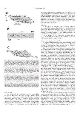
Fig. 4 - Comparison among the structures described in this study (a),
a theoretical strike-slip shear zone (b), and a strike-slip duplex (c). ferent geodetic solutions are obtained in general in differ-
a) The main features recognised in the Southern Tyrrhenian Sea. ent reference frames due to the specific technique observ-
UEL) Ustica-Eolie Line; KAL) Kumeta-Alcantara Line; MF) Maret- able and/or different analysis setup and they could be
timo Fault; SVF) San Vito Fault; PF) Palermo Fault; EF) Etna Fault.
b) Geometry of a theoretical brittle zone of simple shear, where the compared only in a unique global reference frame.
two main shear zone boundary faults (szb) are connected by syn- To derive a unique, homogeneous velocity field from
thetic (R) Riedel Shears. c) Interpretation of the Southern Tyrrhen- the results of the various techniques, each geodetic solu-
ian Sea margin as a strike-slip duplex (STSSD): the NW-SE trending tion is transformed in the ITRF97 reference frame, assu-
faults connecting the main E-W trending boundary faults involve a
minor component of extension, consistent with the results of fault med as the reference model. In order to determine the
kinematic analysis (modified after RENDA et alii, 2000). motion of Eurasia sites representative of the Eurasia rigid
– Confronto tra le diverse strutture descritte in questo lavoro (a), una plate were selected 21, then the ITRF97 cartesian veloc-
zona ideale di taglio semplice (b), ed uno strike-slip duplex (c). a) I ities of these sites was used to derive the parameters of
principali lineamenti del Margine Tirrenico meridionale. UEL) Linea
Ustica-Eolie; KAL) Linea Kumeta-Alcantara; MF) Faglia di Marettimo; the Eurasian plate rigid motion following a least square
SVF) Faglia di San Vito; PF) Faglia di Palermo; EF) Faglia dell’Etna. method. The obtained ITRF97 eurasiatic eulerian vector
b) Geometria di una zona fragile di taglio simplice ideale, dove le due is then used to predict and remove at each considered site
faglie principali (szb) sono collegate tramite Riedel Shears (R) sinteti- the Eurasian velocity. The obtained 3D velocity residuals
ci. c) Interpretazione del Bacino Tirrenico meridionale come uno
strike-slip duplex (STSSD): la figura mostra che le faglie con direzio- represent the site motion with respect to the Eurasia fixed
ne NW-SE, che collegano le faglie principali con direzione E-W, hanno plate. The residuals are mutually differentiated to derive
una debole componente di movimento distensivo, in accordo con i ri- the relative cartesian motion between pairs of sites and
sultati dell’analisi cinematica (da RENDA et alii, 2000, con modifiche). then projected into a proper local LTU reference frame.
The baseline velocities, in the L and T directions, obtai-
ned for each solution are then combined using a weigh-
ted mean method.
GPS analysis The geodetic data have been also used to estimate the
The italian ASI GPS network is part of the EUREF stretching, or strain rate tensor (fig. 3) that provides a
(EUropean REference Frame) network. All the GPS measure of internal deformation within the region and
receivers are permanent stations. The data are routinely the vorticity, or rotation rate tensor, that gives the rigid
analyzed at the CGS using a Fiducial Network analysis body rotation about the local vertical (DEVOTI et alii,
method with the software MicroCosm vs. 9800 (VAN MAR- 1999). In the southern Tyrrhenian basin the three stations
TIN, 1998). It contributes on a regular basis to the EUREF used to estimate the strain tensor are Cagliari, Matera
realization. The analyzed time series runs from January and Noto. The results show a NW-SE directed shortening
1995 till May 1999. A network solution has been per- and a coeaval SW-NE directed extension (fig. 3).