
Page 5 - Gueguen_alii_2002
P. 5
GEODYNAMICS OF THE SOUTHERN TYRRHENIAN 81
1
2
3
MATERA
40°
CAGLIARI
WETTZELL
PADOVA
NOTO
MATERA 10 nano-strain/yr
CAGLIARI
1 mm/yr
1 mm/yr
1 nano-strain =
1000 km
NOTO
1 mm/yr
35°
20°
10°E 15°E 20
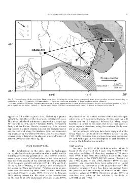
Fig. 3 - General map of the southern Thyrrenian Sea, showing the strain tensor computed from space geodesy measurements (key to
symbols as in fig. 2). Symbols: 1) Strain vector. 2) Error on the strain modulus. 3) Error angle on strain azimuth.
– Schema tettonico del bacino Tirrenico meridionale. È stato rappresentato il strain geodetico ottenuto dai dati di Geodesia spaziale (c.f. fig. 2
per il significato dei retini. Simboli: 1) Vettore dello Strain. 2) Errori sul modulo dello strain. 3) Errori sull’angolo del azimuth.
appear to fall within a great circle, indicating a greater they focused on the relative motion of the different acqui-
variability than that of the maximum compression axes. sition sites with respect to Eurasia. In this work we will
The mean calculated minimum compression axes plunge concentrate on the regional deformation along single
55° towards N215°E, and 37° towards N82°E, for western baselines in order to constrain the strain field across a
Sicily and the Eolian Islands, respectively. It is interest- major regional structure, using the northern Sicily mar-
ing to note that most seismic data for the analysed sector gin as an example.
are concentrated along the Madonie Mts. and surround- All the geodetic solutions have been computed at the
ing areas. Along the Gratteri-Mufara Line the focal mech- Space Geodesy Centre (CGS) in Matera (DEVOTI et alii,
anisms show a dextral strike-slip component (FREPOLI & 1999, 2000). Separate data analyses have been performed
AMATO, 2000; see also their fig. 8). for each technique. A brief description of each solution is
given in the following paragraphs.
SPACE GEODESY DATA VLBI analysis
We used the CGS VLBI EUR98 solution which is
The development of the space geodetic techniques based on the analysis of the 9 years long EUROPE VLBI
during the last decades provides us with a useful tool for campaign, including 42 observing sessions of 24 hours
studying present-day geodynamics. The central Mediter- from 1990 till late 1998. The software used for the VLBI
ranean area is one of the best place to test this new tool data analysis is the CALC/f-SOLVE system (ROGERS et
because of the density of the network and the availability alii, 1983; CLARK et alii, 1985, PETROV 1999). Station
of all the space geodetic techniques (VLBI, GPS and SLR) positions and velocities have been estimated as global
in the station of Matera, or of at least two techniques in parameters, i.e. common to all the analysed sessions. The
the stations of Noto and Cagliari. Previous works on geo- terrestrial reference frame has been constrained fixing
detic data measured by these fixed stations have been the position and the velocity of Wettzell at the corre-
published (DEVOTI et alii, 1999; GUEGUEN & TOMASI, sponding values of ITRF96 (BOUCHER et alii, 1997). A
1998, among others) but, like other recent contributions complete description of the solution is available in
on the results of GPS campaigns (ANZIDEI et alii, 1999), LANOTTE et alii (1999).