
Page 3 - angeo-21-299-2003
P. 3
R. Sorgente et al.: Seasonal variability in the Central Mediterranean Sea circulation 301
by the coarse model. The model domain extension down to 39 −3000 0
31.2 ◦ N captures a large part of the Libyan continental shelf −1800 −500
area and a firsthand valuable contribution to the knowledge North Latitude −100 −3300 −1000
of the circulation in this part of the Mediterranean can be −30038 −100 −1500
derived within the limits imposed by the lack of data and −200 −2000
consequently, the impoverished quality of the climatological 37 −600 −2500
fields in the area. −3000
36 −400
The paper is organized to give a short description of the
characteristics of the general circulation in the area in Sect. 2, 35 −200
and an overview of the model characteristics, including the
treatment of the boundary conditions and the nesting pro- 34
cedures in Sect. 3. An analysis of the main model results
is made in the subsequent section with an emphasis on the 33
seasonal variability. This includes a rigid-lid/free surface
model-model assessment and an analysis of the simulated 32 −3500
volume, heat and salt transport at the Strait of Sicily during −100
the 5-year model integration. A summary and concluding
remarks are made in the final section. 9 10 11 12 13 14 15 16 17
East Longitude
2 Bathymetry, hydrology and general circulation
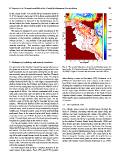
Fig. 2. The model bathymetry of the Central Mediterranean Sea
The geometry of the Sicilian Channel has a great influence on
the dynamics in the area. The fan-shaped configuration of the based on the U.S. Navy bathymetric DBDB1 data set at a resolution
land boundaries has its narrowest constriction on the west- of (1/60)◦. Depth is in meters and the contour interval is 100 m.
ern extremity where the channel between Cape Bon (Tunisia)
and Cape Lilibeo (Sicily) is only 143 km wide. The highly taken during a cruise in November 1994, Robinson et al.
irregular bottom topography in the form of a submarine ridge (1996) have identified seven water masses in the northern
further limits the flow (Fig. 2). This ridge is characterized by area of the Sicily Channel and the northwest Ionian Sea, in-
shallow banks along the Tunisian and Sicilian coast, and a dicating the complexity of the processes in action. But to a
central narrow passageway cutting along the NW-SE axis of first approximation the three main water masses in the strait
the strait, forming part of an intermediate basin with an av- are the upper layer Modified Atlantic Water, which enters
erage depth of 500 m. The African continental shelf is very into the Sicily Channel as an extension of the North African
wide and covers more than one-third of the aerial extent of Algerian coastal current, the deeper Levantine Intermediate
the Strait. In the Gulf of Gabes, the bathymetry is shallower Water (LIW), and a transitional layer between these two wa-
than 30 m for large stretches away from the coast. On the ter masses.
southern coast of Sicily, the shelf is bounded by two wide
(approx. 100 km) and shallow (100 m on average) banks on 2.1 The superficial water
the western (Adventure Bank) and eastern extremities (Malta
Channel area), while it narrows down considerably along its The Atlantic water enters the Mediterranean through the
middle part. Along the eastern coast of Sicily and extending Strait of Gibraltar, becoming warmer and saltier along the
southward, there is the narrow Ionian shelf break which is African coast and constituting the origin of the MAW pro-
very steep to the east of Malta (known as the Malta Escarp- ceeding towards east (Warn-Varnas et al., 1999). In the
ment). The shelf break fans out to the south and subsequently Sardinia Channel the MAW is partially deviated northward
broadens to a gentle slope to the north of Libya. by the shallow Tunisian Skerki Bank (Manzella, 1990) and
then divides into three main branches under the effect of the
The two-sill system at the Strait of Sicily constitutes the bathymetry. One branch enters the Tyrrhenian Sea, flowing
main exchange passageway for the Levantine Intermediate along the northern Sicilian coast; the other two MAW veins
Water (LIW) between the eastern and western Mediterranean flow to the eastern Mediterranean basin crossing the Sicil-
sub-basins. The first sill has a minimum depth of 365 m and ian Channel (Astraldi et al., 1999). The main flow in the
oriented toward north-northwest; the second is deeper, reach- Strait is along the Tunisian coast, while the smaller flux on
ing 430 m and oriented toward north (Frassetto, 1980). The the southern Sicilian shelf gives rise to the northern mean-
major flux occurs through the narrower and deeper eastern dering AIS-Atlantic Ionian Stream (Robinson et al., 1999).
passage close to the Sicilian shelf (Bethoux, 1980). The en-
trance of the LIW from the east occurs mainly at the Medina
sill to the southeast of Malta.
The hydrological data portray a complex structure of the
water masses in the region. From CTD and XCTD profiles