
Page 4 - hydro-maritime_2010
P. 4
made up by calcarenitic coastal sediments of Quaternary Age, which were modelled by periodic eustatic oscillation.
Following a trasgressive phase during the Mean Pleistocene, a calcarenitic-sandy plate formed above the Marsala
calcarenites (named Grande Terrazzo Superiore - G.T.S. after Ruggeri and Unti, 1974 [18] ). Seven maritime terraces lie
between the G.T.S. and a Versiliano terrace [19] at increasing depths (3, 10, 20, 30, 50, 75 and 100 m a.s.l.). Terraces
were identified by alternating steps and erosion planes due to sea regression, highlighting the coastline morphology in
2
3
recent geological periods. The beach is made up of monogranular thin sand (10 -10 μm) with sparse diagenesis in the
Torre Sibilliana area [19] .
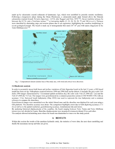
Fig. 1. Computational domain (dashed line) of the study area, with wind and critical wave directions.
3.2 Diachronic analysis
In order to accurately assess both linear and surface variations of Lido Signorino beach in the last 12 years, a GIS based
model has been set-up. Orthophotos acquired between 1994 and 2006 built up the dataset. It includes the grey scale Volo
Italia 1994 images characterized by 1 m nominal spatial resolution (R S), the color scale Volo IT 2000 (R S= 1m) and the
Volo IT 2006 (R S= 0.5 m). The images were georeferenced in a common projection system (UTM WGS84 33N) with an
accuracy ≤ 1m. Surveyed beach bathymetry (May 2010) was used to represent the true bathymetry and a common
reference to compare the shorelines.
Georeferenced images were mosaicked over the whole littoral zone and the shoreline was digitized for each year using a
GIS platform. The shoreline accuracy was about. The comparison highlights errors due to both digitizing accuracy (m 2
m) as well as to the spatial resolution, georeferencing accuracy, instantaneous tide and waves.
By analysing historical displacements of the coastline, the beach ranging between Torre Tunna and Torre Sibilliana
towers were sub-divided in 9 parts. Shoreline displacements were measured in transects distant 50 m each other.
The analysis allowed delimitating areas where the beach was diminished or risen over the study period.
4. RESULTS
Within this section the results of the maritime hydraulic study, the statistics of wave data, the near-shore modelling and
finally the maximum run-up and tides are given.
Proc. of SPIE Vol. 7824 78241Z-4
Downloaded from SPIE Digital Library on 05 Nov 2010 to 151.82.204.68. Terms of Use: http://spiedl.org/terms