
Page 5 - hydro-maritime_2010
P. 5
4.1 Maritime hydraulic study
By analysing the coastline morphology, the wind sector amplitude is 131° and ranges between 195° and 300° N
clockwise (Fig. 1), however the close island of Favignana (the Egadi archipelago) blinds the northern part of the sector
narrowing it to 105° (195°÷300° N). The buoy records vertical oscillation within m 20 m (0.01m resolution and 3%
accuracy) and between 0°÷360° (1.5° resolution and 0.5°÷2° accuracy). The buoy is the only one available close to the
chosen littoral zone and is managed by the Superior Institute for Environmental Protection and Research (ISPRA -
Istituto Superiore per la Protezione e la Ricerca Ambientale) delivering the data. Wave heights, H s [m], maximum and
th
st
mean wave periods, T p and T m [s] and wave direction, D m [°N], between the 1 of July 1989 and 4 of April 2008 were
acquired and processed applying a geographic transposition, to take into account the differences in wind exposition
between the beach and the boundary of the calculation domain. A wave propagation analysis from off to near -shore
allows the retrieval of the beach run-up.
4.2 Statistical analysis of wave data
The ordinary value has been assumed as the minimum of the peak values for each sea-storm, since it is reached at least
once a year during the observational period. The shoreline analysis has been carried out on the 285° N direction,
characterized by the more frequent sea-storms and higher peaks. Between the latter, the minimum value was reached in
2001 (H = 2.18 m) with a period T = 5.51 s (Tab. 1).
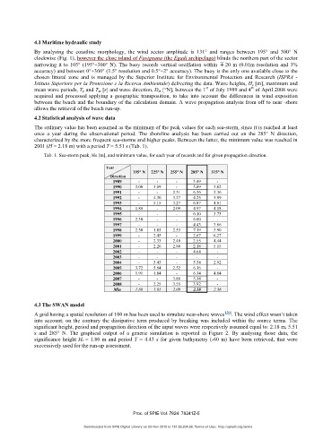
Tab. 1. Sea-storm peak, Hs [m], and minimum value, for each year of records and for given propagation direction.
Year
195° N 225° N 255° N 285° N 315° N
Direction
1989 - - - 3.49 -
1990 2.00 3.09 - 5.89 3.62
1991 - - 2.31 6.26 2.36
1992 - 4.30 3.27 4.25 3.99
1993 - 5.15 3.27 6.87 4.01
1994 1.88 - 2.09 4.97 4.18
1995 - - - 6.10 3.73
1996 2.30 - - 6.00 -
1997 - - - 4.43 3.66
1998 2.50 1.85 2.53 7.19 3.90
1999 - 2.45 - 2.67 6.27
2000 - 2.33 2.49 2.55 4.44
2001 - 2.26 2.88 2.18 5.15
2002 - - - 4.64 -
2003 - - - - -
2004 - 5.43 - 5.54 2.92
2005 3.72 5.64 2.52 6.16 -
2006 1.91 1.84 - 6.34 4.04
2007 - - 3.80 5.14 -
2008 - 2.25 3.55 3.92 -
Min 1.88 1.85 2.09 2.18 2.36
4.3 The SWAN model
A grid having a spatial resolution of 100 m has been used to simulate near-shore waves [20] . The wind effect wasn’t taken
into account; on the contrary the dissipative term produced by breaking was included within the source terms. The
significant height, period and propagation direction of the input waves were respectively assumed equal to: 2.18 m, 5.51
s and 285° N. The graphical output of a generic simulation is reported in Figure 2. By analysing those data, the
significance height Hs = 1.80 m and period T = 4.43 s for given bathymetry (-60 m) have been retrieved, that were
successively used for the run-up assessment.
Proc. of SPIE Vol. 7824 78241Z-5
Downloaded from SPIE Digital Library on 05 Nov 2010 to 151.82.204.68. Terms of Use: http://spiedl.org/terms