Page 6 - EAI-4_2015_12_19
P. 6

the existing maps, the Digital                Research & development
                                                                                      Elevation Model and hyperspectral
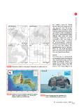
FIGURE 2 Trajectories acquisition of topographic, bathymetric and multispectral data  data acquired under the project
                                                                                      MAMPIRA, the accuracy of which
                                                                                      has been improved thanks to direct
                                                                                      and indirect in-situ investigations.
                                                                                      The seafloor morphology is highly
                                                                                      different with rocky and sandy
                                                                                      shoreface, submarine canyons,
                                                                                      vermetidi’s trottoir and shoals of
                                                                                      high rocky outcrops. A number
                                                                                      of morphological elements
                                                                                      influenced by tectonics,by changes
                                                                                      in sea level and erosion due
                                                                                      hydrodynamics can be observed.
                                                                                      There are also many submerged
                                                                                      forms ever detected so far. Some of
                                                                                      them are described as follows.

                                                                                      6KRDOV
                                                                                      The study area is characterized
                                                                                      by a variety of seafloor geological
                                                                                      and geomorphological features.
                                                                                      South of Favignana Island, at a
                                                                                      depth of 19 to 50m, many rocky
                                                                                      shoals sharply rising from the
                                                                                      bottom were found (Figure 3).

FIGURE 3 Results of the topo-bathymetric surveys of Favignana       FIGURE 4 Draw of Punta Longa Palo, signalled by [5].
              Island. The angle of shading is 315°. Up left a rose                Source: http://favignana.santateresa.enea.it
              diagram of wind speed and direction

                                                                                      15EAI Energia, Ambiente e Innovazione 4/2015
   1   2   3   4   5   6   7   8   9   10