
Page 7 - EAI-4_2015_12_19
P. 7
Research & development
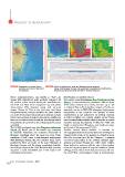
FIGURE 5 Depressions on sandy bottom FIGURE 6 At the top bathymetric, slope and lighting maps are reported.
along the east coast of the island Below, anthropogenic furrows and asymmetry of superimposed sedimentary
of Favignana structures are observed along two NW-SE oriented transects
These morphostructures, also known as “Pali”, are 'HSUHVVLRQVRQVDQG\ERWWRPV
shoals with subvertical walls partially reshaped by The eastern coast of Favignana, from Cala Rossa to Cala
the erosive action exerted during the last Holocenic Azzurra, is characterised by sandstone cliffs of about
sea level rise. They have a subplanar top and, direct 10-15 meters height and a sandy sea floor up to ~20
observations [10] detected steep and terraced m of depth (Figure 5). A detailed analysis of bedforms
slopes (Figure 4). This is the first time that these revealed a series of NNE-SSW elongated depressions
morphostructures, already identified by other authors sub-parallel to the coastline. The genesis of these
[11], have been mapped in a sub-linear and sub circular morphotypes is not influenced by bottom currents
trend. Such geomorphological elements are significant, or relict bedforms (i.e. natural origin), but by trawls
from an ecological point of view, for structuring animal towed during fishing activities that destroy the seagrass
populations, as reported on the submerged itineraries meadow, leaving depressions of different width and
map [12]. depth on the bottom. Therefore, such bedforms were
The 1:12,500 geological map of the Favignana and Levanzo attributed to Anthropocene [13; 14].
Islands [4], shows part of the shoal’s top, composed Another stretch where seafloor is covered by
of dolomitic limestones and dolomites stromatoliti of anthropogenic features is located just north of Favignana
Mesozoic, emerging above the mean sea level. These Village (north centre of the Island), at a depth of about
landforms (“i Pali”) have a morphological convergence 25m. The area was used for the “Tonnare”, a network
with Montagna Grande (the N-S oriented ridge above of several traps fixed to the bottom through large
mentioned). They are made of the same lithology of anchors and stand through the entire water column
Montagna Grande, and the slopes morphology look-like (from bottom to surface) with the aim of intercepting
that of larger slopes of the ridge. Therefore, they probably tunas and capturing them during the “mattanze” (tunas
represent a small remodelled part of this ridge in the killing), activity which made this place famous all over
underwater environment. the world. Their anthropogenic origin is demonstrated
16 EAI Energia, Ambiente e Innovazione 4/2015