
Page 2 - Geomorphological_2020
P. 2
2 M. PAPPALARDO ET AL.
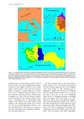
Figure 1. A: Location map of the study area within the Mediterranean basin. B: Structural setting of Western Sicily; (1) Thrust line;
(2) Carbonate platform units; (3) Numidian Flysch units; (4) Synorogenic Deposits; (5) Pleistocene deposits (after: Di Stefano et al.,
2015); the location of the Egadi Archipelago, W of the western coast of Sicily, is shown. C: Structural map of Favignana Island; (1)
fault line; (2) inferred fault line; (3) anticline axis; (4) Plio-Quaternary deposits; (5) Punta Fraraglione unit; (6) Mt. Santa Caterina unit
(after: Ventura Bordenca, 2014).
Tyrrhenian Sea at a short distance from the coast of The only mountain ridge of the Island (Monte
Western Sicily, the largest Mediterranean Island. Santa Caterina, 314 m a.s.l.) separates the Island in
2
Favignana is the biggest (19.8 km )ofthe Egadi two parts of almost equal area with a N–S elongated
Islands and the closest to the coast (4.45 nautical water divide (Figure 2). The remaining part of
miles). It displays a coastal perimeter of 33 km, Favignana is shaped into the form of a tableland,
with an E-W elongated shape. The Island lies on with an average elevation around 10 m a.s.l. on the
the continental shelf that borders Western Sicily east and of 20 m a.s.l. on the west. Geologically
(D’Angelo et al., 2004). The sea bottom is shallow (Figg. 1B and C) Favignana represents an emerged
(within 20 m) between the mainland and the eastern part of the Egadi Thrust Belt (Abate et al., 1995;
coast of Favignana, has an intermediate depth Abate et al., 1997) a sector of the Apenninic–Maghre-
(within 50 m) offshore the Island northern and bian Fold and Thrust Belt (Catalano et al., 1993). In
southern coast and degrades deeply (up to 350 m the Island central ridge and western plain the Upper
ca.) into the so-called Marettimo Trench to the Triassic Sciacca Fm. outcrops (D’angelo, 2005; Mala-
west (Nautical Chart n° 260 Litorale tra Trapani e testa, 1957). This is represented by dolomites and
Marsala e Isole Egadi,IstitutoIdrografico della Mar- dolomitic limestones with mollusks, algae and forami-
ina, www.marina.difesa.it). nifera. They are layered and partly intercalated,