
Page 5 - Geomorphological_2020
P. 5
JOURNAL OF MAPS 5
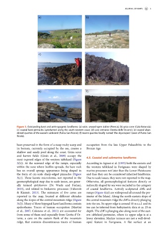
Figure 3. Outstanding karst and anthropogenic landforms: (a) wide, seward-open doline (Pirreca); (b) griza scree (Cala Rotonda);
(c) coastal karst pinnacles (spitzkarren) along the south-western coast; (d) cave entrance (Grotta delle Uccerie); (e) coastal aban-
doned quarries of the eastern tableland (Punta San Nicola); (f) recent quarries locally named ‘the skyscrapers’ (west of Punta San
Nicola).
been preserved in the form of a steep rocky scarp and occupation from the late Upper Palaeolithic to the
its bottom, currently occupied by the sea, creates a Bronze Age.
shallow and sandy pool along the coast. Griza scree
and karren fields (Ginés et al., 2009) occupy the
4.5. Coastal and submarine landforms
most exposed edges of the western tableland (Figure
3(b)). At the seaward edge of the ramps, especially According to Agnesi et al. (1993) both the eastern and
within the zone where biofilm spreads, the bare rock the western tableland in Favignana were shaped by
has an overall spongy appearance being shaped in marine processes not later than the Lower Pleistocene
the form of cm-scale sharp-edged pinnacles (Figure and thus they can be considered inherited landforms.
3(c)). These karstic microforms, not reported in the Due to scale issues, they were not reported in the map.
geomorphological map due to scale issues, are gener- Otherwise, all geomorphological features directly or
ally termed spitzkarren (De Waele and Furlani, indirectly shaped by sea were included in the category
2013), and related to biokarstic processes (Taboroši of coastal landforms. Actively sculptured cliffs and
& Kázmér, 2013). The entrances of five caves are ramps (Figure 4(a)) are widespread all around the per-
reported in the map, located at different altitudes imeter of the Island. Along the north-eastern slope of
along the slopes of the central mountain ridge (Figure the central mountain ridge the cliff is directly plunging
3(d)). Many of these hypogeal karst landforms contain into the sea. Its upper edge is around 10 m a.s.l. and its
speleothems. Traces of human occupation (Martini toe can be inferred from bathymetric data at ca. 25 m
et al., 2007; Colonese et al., 2011) are accounted for depth. The cliff is plunging also along most of the east-
from some of them and especially from Grotta d’Or- ern tableland perimeter, where its upper edge is at a
iente, a cave on the eastern flank of the mountain lower elevation. Marine terraces are not a well-devel-
ridge, that contains discontinuous traces of human oped feature in Favignana. A flat surface at an